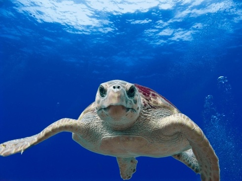
OCEANOGRAPHY
Photo Credit:US National Oceanic and Atmospheric Administration
Links added 6/29/2017
AMERICAN ADMIRALTY BOOKS PRIVACY POLICIES NOTICE
 American Admiralty Books does not use "cookies", Google as system provider, and third party advertisers on this site do use cookies as do sites we link to. There is no "block cookies" option for Google, to visit this site is to agree to the Google privacy policy linked to above. By not clicking on links within the site you avoid third party cookies. Visitors may read posts and special interest sections without incurring any cookies known to us other than those described in the Google Privacy statement linked above. Many posts and all special interest sections contain links to related Amazon books, videos and other related products. If you enter Amazon through our links you agree to the Amazon privacy policy linked above. Any links cited as "Read More" may take you to publishers on subjects addressed in this blog who may or may not use cookies. EUROPEAN VISITORS ARE WARNED THAT MOST ADVERTISERS AND "READ MORE" SOURCES LINKED TO, ARE AMERICAN AND NOT SUBJECT TO THE EU REQUIRED NOTICES INVOLVING "COOKIES". WE CAN NOT ASSURE VISITORS TO THIS SITE THAT ANY VISIT WILL NOT RESULT IN THE DELIVERY OF "COOKIES". IF "COOKIE ADVERSE" ENTER AT YOUR OWN RISK. THIS NOTICE SUPPLEMENTS THE REQUIRED EU NOTICE PROVIDED BY GOOGLE TO EU VISITORS. IF YOU DID NOT SEE THE REQUIRED EU NOTICE BEFORE ENTERING OUR SITE PLEASE REPORT THE INCIDENT IN THE COMMENTS SECTION AT THE END OF ANY SCROLLED PAGE. THANK YOU.
Advertisement:

TEMPORARY POST: Go to g Captain for a new video of recently discovered deep sea marine life filmed for the first time in the ocean depths off Puerto Rico.
AMERICAN ADMIRALTY BOOKS PRIVACY POLICIES NOTICE
"COOKIES NOTICE" : HOW GOOGLE USES DATA:
American Admiralty Books does not use "cookies", Google as system provider, and third party advertisers on this site do use cookies as do sites we link to. There is no "block cookies" option for Google, to visit this site is to agree to the Google privacy policy linked to above. By not clicking on links within the site you avoid third party cookies. Visitors may read posts and special interest sections without incurring any cookies known to us other than those described in the Google Privacy statement linked above. Many posts and all special interest sections contain links to related Amazon books, videos and other related products. If you enter Amazon through our links you agree to the Amazon privacy policy linked above. Any links cited as "Read More" may take you to publishers on subjects addressed in this blog who may or may not use cookies. EUROPEAN VISITORS ARE WARNED THAT MOST ADVERTISERS AND "READ MORE" SOURCES LINKED TO, ARE AMERICAN AND NOT SUBJECT TO THE EU REQUIRED NOTICES INVOLVING "COOKIES". WE CAN NOT ASSURE VISITORS TO THIS SITE THAT ANY VISIT WILL NOT RESULT IN THE DELIVERY OF "COOKIES". IF "COOKIE ADVERSE" ENTER AT YOUR OWN RISK. THIS NOTICE SUPPLEMENTS THE REQUIRED EU NOTICE PROVIDED BY GOOGLE TO EU VISITORS. IF YOU DID NOT SEE THE REQUIRED EU NOTICE BEFORE ENTERING OUR SITE PLEASE REPORT THE INCIDENT IN THE COMMENTS SECTION AT THE END OF ANY SCROLLED PAGE. THANK YOU.Advertisement:
William H. Toohey III AFNI
Toohey Marine LLC
Master Unlimited
ISO 9001:2015 Lead Auditor Class
(Bureau Veritas)
(Bureau Veritas)
ISM Lead Auditor (ABS Certified)
IMCA CMID Vessel Inspector
Vessel Compliance/Training/Safety Officer
Cell: 504-432-1958
Email: skiffrunner@gmail.com
TEMPORARY POST: Go to g Captain for a new video of recently discovered deep sea marine life filmed for the first time in the ocean depths off Puerto Rico.
WELCOME TO OUR OCEANOGRAPHY SECTION:
If we had a theme song for this section it would be : OCEAN's BLOOD by Bella Gaia
If we had a theme song for this section it would be : OCEAN's BLOOD by Bella Gaia
The world's oceans occupy roughly 71 percent of the earth's surface and by some estimates 99 percent of its biosphere, or livable volume. Oceanography is the study of this vast habitat. To understand the oceans, the oceanographer requires a solid foundation in the principles that underlie marine biology, physical and chemical oceanography, hydrodynamics, and dare we add; international law and politics, many aspects of marine technology, and some practical skills in the nautical arts and sciences. Professional oceanographers tend to specialize. The professional oceanographer is not the only marine professional who needs a growing knowledge of the collection of arts and sciences that constitute "Oceanography." Today's Merchant Marine Officer, Naval Officer, Coast Guard Officer, naval architect, coastal civil engineer, and countless others impact the oceans and coastal environments and are in turn impacted by oceanography based legal, regulatory, moral, and practical considerations that help define, limit, or expand their work.
Just a few of the concerns of the oceanographer include, underwater acoustics, the impact of noise, photosynthesis, trophic interactions and energy flow, and the impacts of human activities on marine and atmospheric systems. These concerns in turn impact naval planning, waterfront development, marine design, offshore mineral exploration just to name a few activities of man that impact the ocean and coastal environments, and are in turn impacted by consideration of that environment. The growing ethical consideration is driven by the work of the oceanographer whose research both educates the public to a higher ethic of consideration for the maritime environment, and drives protective legislation and regulation.
There is a vast and constantly growing body of work in oceanography. Our oceanography section is under construction and just getting started. We have aboard a practicing oceanographer who will assist us in wading through, describing, and recommending oceanographic literature. In this section we have for you a wide variety of books but also some very special video and audio "special features" which may help you explore the ocean world or a possible career in one branch or another in Oceanography. Books, special features, and videos are spread throughout the section at the moment in no real semblance of order, but the section is not very large. So be sure to scroll to the bottom before concluding that you couldn't find what you wanted.
This endeavor, like all sections of the American Admiralty Books will take quite a while to fully develop. We appreciate all of our readers interest in this section. If you are new to Oceanography we have found a moderately priced college level introductory text that we feel we may suggest as a "first read," we'll have a lot more later. Please continue to watch this space.
AMAZON'S OCEANOGRAPHY BOOKSHELF HUNDREDS OF TITLES ON OCEANOGRAPHY (link updated 12/1/2015)
Below is a link to the Scripts Institute of Oceanography's News Service, the best on line free periodical on oceanography around. Below the link our book reviews, videos, links to free videos begin:
Below is a link to the Scripts Institute of Oceanography's News Service, the best on line free periodical on oceanography around. Below the link our book reviews, videos, links to free videos begin:
Here are some links to introductory videos on the general science of oceanography:
Introduction to Oceanography (Part 1): History & Ocean Basics
Introduction to Oceanography (Part 2): History & Tools
Introduction to Oceanography (Part 1): History & Ocean Basics
Introduction to Oceanography (Part 2): History & Tools
...........................................................................................................................................................................................
DRIFT DIVE: Take a virtual dive in over 1,000 feet of water in the middle of the night in America;s newest and the world's largest marine reserve.
...........................................................................................................................................................................................
FIVE FABULOUS OCEAN VIDEOS :
 PD Image
Below are five videos ranging in length from about 3 minutes to nearly an hour and half. We selected these because of their beautiful photography, educational value, and what we call "infotainment" factor. Right after the title we provide an estimate of the video's running time. Vocational / technical educators say that we retain only about 10% of what we read, 50% of what we see and hear, and about 90% of what we say and do. Well, we can't take you diving, but we suggest that if you watch these videos on some interesting oceanographic topics, and watch again while taking notes, your retention will increase to close to that 90% level for whatever purpose that you might have in learning more about the ocean. These videos after initial appearance on our daily blog post will be permanently featured in our OCEANOGRAPHY SECTION
American Admiralty Books Safety & Privacy Policies EU VISITORS WARNING POSSIBLE COOKIES AHEAD
EIGHT FACTS ABOUT THE OCEANS 3 Min.
TOP TEN OCEAN PHENOMENA about 8 minutes
NEVER SEEN CREATURES FROM THE BOTTOM OF THE SEA: about 45 minutes
BLUE HOLES : 1 hr, 28 min
...........................................................................................................................................................................................
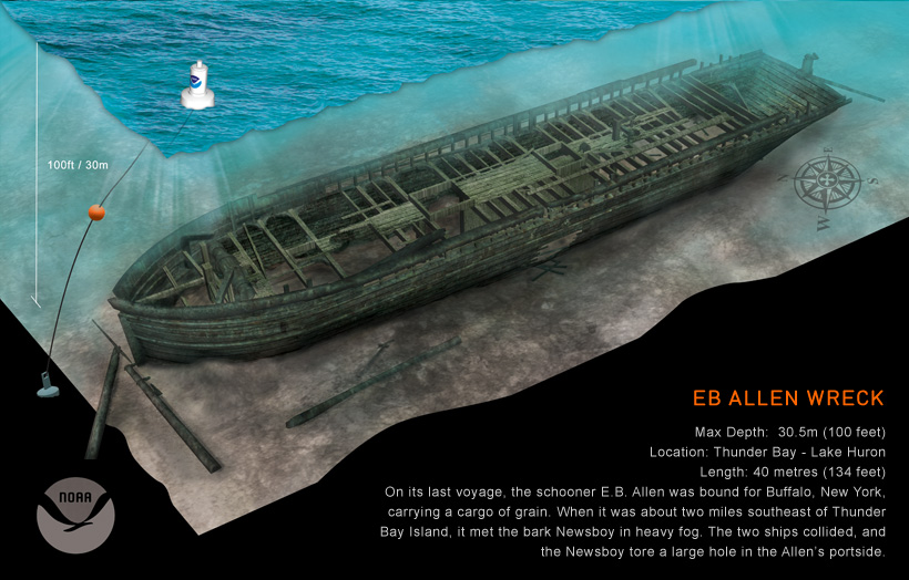 |
| Image by NOAA & Thunder Bay Marine Sanctuary |
Click here to take an underwater tour of the well preserved ship wreck the E.B. ALLEN, sunk November 20, 1871. This ship wreck and many others are protected by the National Atmospheric and Oceanic Administration's Marine Sanctuary Program. On scene research and enforcement is often conducted by America's least known and smallest naval service the NOAA CORPS.
GPS Location: N45° 00.976’ W83° 09.899’
Depth: 100 Feet
Wreck Length: 134 Feet
Beam: 26 Feet
Gross Tonnage: 276
Cargo: Grain
Launched: 1864 by H.C. Piersons at Ogdensburg, New York
Wrecked: November 20, 1871
Description: On its last voyage, the E.B. Allen was bound for Buffalo, New York, carrying a cargo of grain. When it was about 2 miles southeast of Thunder Bay Island, it met the bark Newsboy in heavy fog. The two ships collided, and the Newsboy tore a large hole in the Allen’s portside. As the ship began to sink, the Allen's crew was removed and taken on board the other vessel. Today, theE.B. Allen sits on an even keel, with its hull largely intact. Although the masts are broken and most of the decking is gone, the windlass, anchor chains, and rudder are still in place.
-----------------------------------------------------------------------------------------------------------------------------------------------------------------
AMAZON'S OCEANOGRAPHY BOOKSHELF Link updated 12/1/2015
Our suggestion for a "first read" in oceanography is:
.............................................................................................................................................................................................

Image Courtesy South Florida Water Management District
If you have been following our coverage of Hurricane Irma the last few days you may have noted that we based our prediction that the Central and Western Gulf Coast would be unscathed by the storm based on an analysis of "Spaghetti Tracks". If you are interested in learning how "Spaghetti Tracks" are assembled, used and interpreted we suggest clicking in to Weather Nerds.org .
"Spaghetti Tracks" are just one of the things you can learn about with Weather Nerds.org . This is a great sight for learning how to better understand national and regional forecasts and using the information provided by these official forecasts for you own micro forecasts when you are trying to make those last minute decisions such as do I have time to get to the grocery and back before the street flooding hits here? Do I have time to get to the marina to secure the boat without getting stranded on the way back? Weather affects all of our lives profoundly, the more outdoor elements in your occupation the more dramatic the potential effects. As always we remind everyone never drive through standing water of any height. If you occasionally have to chance a car or boat run as a storm is approaching, your life may depend on your personal micro cast. Some serious study in advance could save your life or property. Weather Nerds.org . is a great place to start your studies.
DISTANCE LEARNING OPPORTUNITY
https://www.mla-uk.com/
THE MARINE LEARNING ALLIANCE & HYDROGRAPHIC ACADEMY OF PLYMOUTH UNIVERSITY
E-courses in meteorology, oceanography, data management, hydrography, marine operations, navigation, underwater acoustics, maritime law: Study on line for degree and certificate programs or down load & study from your lap top at sea.
............................................................................................................................................................................................
HOW THE OCEAN WORKS : AN INTRODUCTION TO OCEANOGRAPHY By Mark W. Denny, published in 2008
ISBN-10: 069112547X
USBN-13: 978-069112470
In this college level (01) text each chapter is focused on a major topic and carefully explains the principles and theory involved. The book introduces the reader to each of the conceptual building blocks needed to develop a coherent picture of the living ocean as we understand it today. How the Ocean Works is an easy to read introduction that leads the reader that teaches readers how to begin thinking about the ocean and its biology, mechanics, and conservation. The book provides a reasonably up to date introduction to the ocean sciences, helps impart the conceptual basis of how the ocean "works," explains basic principals and theory, and includes color illustrations and diagrams. Very importantly for those who need a starter text and are not professional oceanographers the book is reasonably priced. We have included a link to the Amazon site for the book. Readers who venture into the many other texts currently published on oceanography which can be reached from this site in the Amazon system will note that many technical works on oceanography retail for well over $100. Our "suggested first read" retails for under $40 on our last check. If nothing else would impel us to undertake the review of the vast collection of English language literature on Oceanography book prices for many of the important works motivate us to provide our readers with the type of guidance that you will find goes well beyond what the direct book sellers offer. Fortunately the beginner in oceanography can get off to a running start with "How The Ocean Works: An Introduction to Oceanography" without going into hock.
AMAZON'S OCEANOGRAPHY BOOKSHELF link updated 12/1/2015
NEW FEATURE: WATCH THE LATEST EXPEDITIONS OF DR. ROBERT BALLARD AND HIS "CORPS OF EXPLORATION: FIRST PERSON ACCOUNTS AND VIDEOS:
NAUTILUS LIVE
Amazon - Shop. Connect. Enjoy. All from Earth's Biggest Selection.
THE COMPLETE 400 Volume Library of HMS BEAGLE As Used By Darwin,On Line:
When Darwin put to sea on the HMS BEAGLE he didn't just bring blank notebooks, but relied heavily on a compact but fairly complete set of references on known biology, geology, and botany. Darwin's make shift personal quarters and laboratory also served as the ship's library. Unfortunately the library was dispersed after the voyage and until recently the contents of Darwin's references were unknown. Today 178 years later John van Wyhe of the National University of Singapore has reconstructed, a virtual version of Darwin’s library, by cataloging all of the printed sources Darwin made reference to in his travel notes. Dr van Wyhe has found the texts of these now rather obscure volumes that Darwin would become so familiar with and has scanned them into on line versions that scholars, journalists, historians, and others may access at no charge. The entire project has been generously supported by the National University of Singapore..You may read the full story of this daunting feat of research and publishing at Take a Virtual Voyage into Darwin's Library. You can literally read scanned versions of the library publications at CHARLES DARWIN's BEAGLE LIBRARY.
We think this is an invaluable resource and service, a light that should never be hidden under a basket.. Since we don't have room yet for a VOYAGES OF DISCOVERY section in its own right we're going to post this as an illustrated post in several likely sections where someone looking for such information might think to look within our present system. As long as this valuable resource is up on the internet we will endeavor to track it and link you to it. We can't possibly replicate all of the fantastic research in the maritime context that is going on out there. But we view it as our job to try and learn everything that is going on and to make it easier to find .
.............................................................................................................................................................................................

com/acoustics/index.html
.............................................................................................................................................................................................
NEW FEATURE: WATCH THE LATEST EXPEDITIONS OF DR. ROBERT BALLARD AND HIS "CORPS OF EXPLORATION: FIRST PERSON ACCOUNTS AND VIDEOS:
NAUTILUS LIVE
............................................................................................................................................................................................
THE OCEANOGRAPHY CAREER THAT THEY DON'T TELL YOU ABOUT IN SCHOOL. CALLED THE "WET NASA" THE NOAA CORPS ACTUALLY DATES BACK TO THE LEWIS AND CLARK EXPEDITION
 |
| THE NOAA FAIRWEATHER IN ALASKA NOAA PHOTO |
The NOAA Corps is probably the least known of the seven uniformed services of the United States. The Army, Navy, Marine Corps, and Air force are uniformed services and also armed services in the Department of Defense. The U.S.Coast Guard is a uniformed service, law enforcement agency, and armed service in the department of Homeland Security, and a separate service within the Navy in times of war or when so ordered by the President. The U.S.Public Health Service is a uniformed service , naval in character. Its uniformed members wear naval type uniforms and are assigned naval rank. The USPHS does not carry arms but is charged with the more arduous duties related to guarding our ports of entry from invasion by pests and disease, providing medical services to the U.S.Coast Guard , assisting the Department of Homeland security in guarding against biological attack, curbing epidemics, and augmenting the naval medical corps in time of war. The National Oceanographic and Atmospheric Administration's Officer Corps (NOAA CORPS) is the smallest uniformed service. With less than 400 uniformed commissioned officers it too is naval in character, rank, and uniforms. The primary duty of the NOAA corps is to operate the NOAA fleet of research and charting vessels and carry out the more arduous research duties of the service such as camping out on ice flows to gather data,, flying into hurricanes, anything involving diving, and important projects in coastal regions where time is short, pressure is high, and living conditions not to the liking of the typical civilian. The Corps also augments the Navy and Coast Guard particularly in oceanographic science missions as needed war or not. Some NOAA ships were armed in WWII and some may carry small arms for self defense in high risk areas today. The service traces its history as a continuous organization back to the "Coast Survey" of 1807 which was largely inspired by the Lewis and Clark "Corps of Discovery"which returned the year before the Coast Survey" was started. The primary work product of the NOAA corps is the gathering of the raw data that goes into the NOAA produced navigation charts and navigation publications such as the "COAST PILOT". If you are a young physically fit person interested in a career in oceanography and navigation use the link below to learn more about the NOAA Corps:
NOAA OFFICER CORPS
The NOAA mission has been described as :
"...to understand and predict changes in the Earth's environment, from the depths of the ocean to the surface of the sun, and to conserve and manage our coastal and marine resources."
This summer 2011 ice cover melt in the high Arctic was record breaking. All predictions are for more reduced summer ice conditions far into the future. This means much more interest in Arctic ocean navigation in season not just by naval forces, and scientific vessels, by also by ordinary shipping taking a short cut from the North Pacific to North Atlantic ports,and even tourist voyages, and of course oil exploration. The routes used will cover many areas that were last charted by Capt. James Cook around 1778. It's up to NOAA and its Corps to change that situation. In 2011 NOAA issued its' Arctic Nautical Charting Plan, a major effort to update Arctic nautical charts for the shipping lanes , approaches, and ports along the Alaskan coast. In July2011 the FAIRWEATHER began a 30 day mission to survey a track line along the coast to validate information submitted by commercial and naval vessels and identify areas in need of survey by NOAA assets. The opening of the High Arctic to commercial shipping is posing a challenge to the U.S. Government. while the Coast Guard is experimenting and researching ways to establish a persistent presence in this harsh though moderating environment the NOAA corps and its civilian seamen are still doing what Lewis and Clark did in the early days of the Republic, blazing the trail. If you would like more information on the voyage of the FAIRWEATHER click on this link: http://www.noaanews.noaa.gov/stories2012/20120730_fairweather.html
To learn more about NOAA in general click here: http://www.noaanews.noaa.gov/stories2012/20120730_fairweather.html :
Amazon - Shop. Connect. Enjoy. All from Earth's Biggest Selection.
...........................................................................................................................................................................................
...........................................................................................................................................................................................
THE NOAA CORPS, DON'T LET ITS MISSION GET LOST IN MORASS OF COAST GUARD MISSIONS CREEP
|
| THE NOAA FAIRWEATHER IN ALASKA NOAA PHOTO |
The NOAA Corps is probably the least known of the seven uniformed services of the United States. It is part of the larger "Naval Establishment", its officers carry naval rank, and it provides vital services to the Navy, Coast Guard, and Merchant Marine. The Army, Navy, Marine Corps, and Air force are uniformed services and also armed services in the Department of Defense. The U.S.Coast Guard is a uniformed service, law enforcement agency, and armed service in the department of Homeland Security, and a separate service within the Navy in times of war or when so ordered by the President.
By Contrast, U.S.Public Health Service is a uniformed service , naval in character. Its uniformed members wear naval type uniforms and are assigned naval rank. The USPHS does not carry arms but is charged with the more arduous duties related to guarding our ports of entry from invasion by pests and disease, providing medical services to the U.S.Coast Guard , assisting the Department of Homeland Security in guarding against biological attack, curbing epidemics, and augmenting the naval medical corps in time of war. The National Oceanographic and Atmospheric Administration's Officer Corps (NOAA CORPS) is the smallest uniformed service. With less than 400 uniformed commissioned officers it too is naval in character, rank, and uniforms. The primary duty of the NOAA corps is to operate the NOAA fleet of research and charting vessels and carry out the more arduous research duties of the service such as camping out on ice flows to gather data,, flying into hurricanes, anything involving diving, and important projects in coastal regions where time is short, pressure is high, and living conditions not to the liking of the typical civilian. The Corps also augments the Navy and Coast Guard particularly in oceanographic science missions as needed war or not.
Some NOAA ships were armed in WWII and some may carry small arms for self defense in high risk areas today. The service traces its history as a continuous organization back to the "Coast Survey" of 1807 which was largely inspired by the Lewis and Clark "Corps of Discovery"which returned the year before the Coast Survey" was started. The primary work product of the NOAA corps is the gathering of the raw data that goes into the NOAA produced navigation charts and navigation publications such as the "COAST PILOT". If you are a young physically fit person interested in a career in oceanography and navigation use the link below to learn more about the NOAA Corps:
NOAA OFFICER CORPS
The NOAA mission has been described as :
"...to understand and predict changes in the Earth's environment, from the depths of the ocean to the surface of the sun, and to conserve and manage our coastal and marine resources."
We bring up the NOAA Corps and fleet for the second time since last summer because the acquisition of the fleet by the U.S. Coast Guard was discussed on page 31 of the highly respected Naval Institute PROCEEDINGS August 2013 issue. In an article titled "REINVENT THE FIFTH ARMED SERVICE QUICKLY" authors Cpatain Jim Howe, USCG (ret.) and Lieutenant Jim Dolbow, USCGR http://www.usni.org/magazines/proceedings/2013-08/reinvent-fifth-armed-service-quickly described the NOAA fleet and suggest either direct acquisition by the Coast Guard or at least closer cooperation. In the article they mention that the NOAA Officer Candidate School is moving to the grounds of the Coast Guard Academy. We think it is time to sound a cautionary note. While we are in favor of closer cooperation and coordination between the NOAA Corps, its fleet and air arm, we think assimilation into the Coast Guard is a terrible idea. One of the reasons for the Coast Guard's present shortage of floating patrol assets is "mission creep". The Coast Guard began life as a floating criminal law enforcement agency with permissive authority to perform search and rescue , and a stand by role as a naval auxiliary. The Coast Guard was from its earliest inception as the "Revenue Marine" an armed service "and more". The Coast Guard grew by assimilating other paramilitary agencies with federal maritime missions such as the U.S. Life Saving Service, and U.S. Light House Service, and later the Bureau of Steam Navigation. After being renamed "The U.S. Coast Guard" more civil maritime missions continued to be added. As warfare in the last decade of the 20th century became increasingly asymmetric the Navy and even the Army found more and more uses for Coast Guard "niche" military skills and the national defense role as well as the homeland security role of the Coast Guard increased dramatically as did demands on manpower, vessels and Aircraft. Budgets did not increase proportionately.
Throughout this entire time of explosive mission growth for the U.S. Coast Guard the Congress of the United States was busily shooting the American tax payer and themselves in the foot with bloated over extended budgets for everything but the things the nation really needs. Now with the self inflicted requirement of sequestration the Congress is mandated to reduce the budget by massive across the boards cuts but with the majority coming from "national defense". The Coast Guard's multi-mission platforms and personnel already over burdened, are receiving major budget cuts as part of sequestration.
In the past months we brought you the story of the grounding of the USS GUARDIAN in the Pacific in Philippine waters.http://americanadmiraltybooks.blogspot.com/2013/02/2132012-naval-interest-guardian-salvage.html The reef that the USS GUARDIAN grounded on is actually about 8 nautical miles from its charted position. Some modern charts of parts of the Pacific are still based on the charts and logs of Captain Cook. The NOAA Corps charting work is far from done and like everything else of real national importance takes a back seat in funding to whatever special interests help congressmen stay in office. The two Naval Institute PROCEEDINGS authors were proposing the reinvention of the Coast Guard because frankly the Coast Guard is sinking in a morass of unfunded mandates, terminal mission creep. The Navy, the Coast Guard, the Merchant Marine, The Offshore Oil Industry and countless others need the navigation charts, publications, research, and other work products of the NOAA Corps. These are not Homeland Security functions but properly are considered Department of Commerce functions with defense utility. NOAA's fleet, air arm, and uniformed corps are under funded as the sorry state of Pacific charts indicates, but at least they are separately funded. Their mission is sheltered from the automatic sequestration cuts aimed at armed forces. This is no time to expose these vital national assets to the current insanity in Congress. If no one else in government has the intelligence to say no to creeping Coast Guard acquisition of the NOAA fleet and corps the general public must tell their Congressmen to leave the NOAA fleet and corps intact and in the Commerce Department. This is a tough call because the average American is completely unaware that the NOAA Corps exists.
Underlying all of the problems of Coast Guard mission creep, inadequate Naval budgets that won't even allow the repair of the burned USS MIAMI, threats to the NOAA Corps, a disappearing Merchant Marine, and an offshore oil industry over run with foreign flag vessels is the utter lack of a coherent national maritime policy. In Congress today serious maritime experience among the members is even more rare than honorable discharges which are scarce as hen's teeth. Please pass this post on to everyone you know. We encourage all of our readers regardless of what maritime or nautical interest brings you to our pages to read about naval and commercial maritime issues. We live in a nation that derives its economy from about 77 strategic materials 66 of which have to be imported by sea. We are a maritime nation led by a government composed of landlubbers. We have a government that is clueless in terms of a coherent national maritime policy. If the demand for such doesn't come from the people it isn't going to happen. The price on all of us will be very high. The days when we simply could maintain the world's biggest Navy out of our economic surplus and play the 300 pound gorilla when we didn't know exactly what to do are over. Today we have to act intelligently in the maritime sphere or withdraw to "Fortress America", which will be no fortress to the rising naval powers, especially after the present administration finishes disarming the citizenry.
...........................................................................................................................................................................................
THE COMPLETE 400 Volume Library of HMS BEAGLE As Used By Darwin,On Line:
THE LIBRARY OF THE BEAGLE IS NOW ON LINE
When Darwin put to sea on the HMS BEAGLE he didn't just bring blank notebooks, but relied heavily on a compact but fairly complete set of references on known biology, geology, and botany. Darwin's make shift personal quarters and laboratory also served as the ship's library. Unfortunately the library was dispersed after the voyage and until recently the contents of Darwin's references were unknown. Today 178 years later John van Wyhe of the National University of Singapore has reconstructed, a virtual version of Darwin’s library, by cataloging all of the printed sources Darwin made reference to in his travel notes. Dr van Wyhe has found the texts of these now rather obscure volumes that Darwin would become so familiar with and has scanned them into on line versions that scholars, journalists, historians, and others may access at no charge. The entire project has been generously supported by the National University of Singapore..You may read the full story of this daunting feat of research and publishing at Take a Virtual Voyage into Darwin's Library. You can literally read scanned versions of the library publications at CHARLES DARWIN's BEAGLE LIBRARY.
We think this is an invaluable resource and service, a light that should never be hidden under a basket.. Since we don't have room yet for a VOYAGES OF DISCOVERY section in its own right we're going to post this as an illustrated post in several likely sections where someone looking for such information might think to look within our present system. As long as this valuable resource is up on the internet we will endeavor to track it and link you to it. We can't possibly replicate all of the fantastic research in the maritime context that is going on out there. But we view it as our job to try and learn everything that is going on and to make it easier to find .
.............................................................................................................................................................................................
Listen to The Deep: A Special Link and Fun Informative Experience
Click below for special feature or anywhere in the article where you see the hyper-link below

| Listen to The Deep is Recommended by Namazu the Earth Shaker, Former Japanese Giant Catfish Demigod: "I love this technology without it I'd have to take human form weekly just to do my posts" |
Photo Credit:US National Oceanic and Atmospheric Administration
listentothedeep.com (click here for feature)
This listing isn't about a book. As we build our Oceanography site one subject that has spawned many volumes of text, and will spawn a number of book reviews here, is subsurface acoustics. Sound travels about five times faster in water than in the air and many marine species from fish to mammals make extensive use of sound for sensing and communications. That includes man;once we began to transit the seas in submarines and to hunt submarines from surface ships. This spawned the technology of SONAR. However even before we began to deliberately make sounds we were emitting a great deal of sound underwater as soon as we invented the steamship.
Recent studies show that the sound of a passing ship on the surface dominates the subsurface sound scape to a depth of over a mile. The sound travels laterally through the water omni- directionally as well, perhaps for hundreds, if not thousands of miles. Our ability to estimate the lateral distance such sounds travel is limited by our passive listening technology which is constantly improving but hasn't yet reached the level of whale passive listening. It has been determined that certain whales can detect the "songs" of other whales at a distance of as much as 2,000 miles depending on a number of factors.
Oceanographers who have studied whale and dolphin communications have found sounds so complex and varied that they often speak of them as "language." Imagine the complexity of whale and dolphin society. Not only do they exhibit a complex communication system it is long range and high speed. If sound travels five times faster in water than in air that makes the speed of oceanic sound on the rough order of 3,000 miles an hour. Whales a thousand miles apart are receiving communications in about 20 minutes. Whales and dolphins only a few to a 100 miles apart experience communications from individuals and pods almost instantly. Into the middle of this super complex and information loaded acoustic environment mankind is broadcasting daily intentionally and unintentionally an ever increasing volume of sound, some as information rich as the whale's song. Fortunately we have also begun to listen. Now anyone with access to the Internet can listen along with the scientist.
To help the scientific community and the public appreciate just how noisy the oceans have become Michel Andre, a bio acoustics expert at the Technical University of Catalonia in Barcelona has created a website listentothedeep.com which streams live sounds of the ocean floor from a vast loop of sea floor sensors off of Vancouver, Canada and 14 other sea bottom "observatories" around the world. We mention the Vancouver based "observatory" because it illustrates a problem of such observatories. The Canadian monitor loop encompasses a vast region of the North Pacific that is important to for American and Canadian naval operations including U.S. nuclear submarine activity. The sound feed from that sensor is first passed to a naval processing center which removes the sounds of war ships and returns the processed signal back to the website for broadcast minus the sounds of warships.
This relates to a topic of concern that you may find in our Naval Interest section soon, the increasing difficulty of achieving "stealth" for war ships and planes in the sense of emissions reduction to below detection threshold. Detection capability keeps escalating as availability spreads from highly sophisticated and expensive equipment owned by superpowers and their allies to anyone with a computer.
The sounds of the ocean at listentothedeep.com have been processed to bring them into human audible range since most are at a higher frequency. The sounds are also accompanied by color graphs providing information about the sounds. Follow our link to the opening page, index of listentothedeep.com. and listen to the acoustic environment of 71% of the Earth's surface and 99% of its biosphere. You'll not be listening to how the "other half lives" but how the majority of life on earth communicates. The link below is for direct access to th elistening page and accompanying graphs.
Here are some other "Songs of the Deep" click on the hyper-links, click on "full screen", crank up the audio and enjoy!
SONG OF THE WHALES FEATURING GREEN PEACE AND SEA SHEPARD FOOTAGE
A SONG BY THE WHALES, NO MUSIC ONLY OCEAN SOUNDS WITH ACTUAL WHALE SONG
http://www.youtube.com/watch?v=JJZVQ-rIiP0
OCEANOGRAPHY BOOK SHELVES
.............................................................................................................................................................................................
SHERMAN'S LAGOON
 Copyright 2014 by Jim Toomey distributed by King Features Syndicate 14 Jim Toomey | Distributed by King Features Syndicate
- © 2014 Jim Toomey | Distributed by King Features Syndicate
Sherman is a great white shark who is uniquely unaware of how intimidating he can be. He is the main character in SHERMAN'S LAGOON set somewhere in the tropical seas and inhabited by a cast of unique characters. Sherman gets pushed around a bit by these other characters including Hawthorne, a hermit crab, Fillmore the sea turtle, and Megan, Sherman's domineering wife, another great white shark. The characters in Sherman's lagoon lead lives an awful lot like middle class Americans. They try new business ventures, go on dates, have family issues. But they also have problems unique to life in the lagoon, like what to bring to a covered dish party; shrimp...will shrimp be there?
There is also an ocean environmental aspect to the cartoons. Ocean environmental themes are explored in a humorous non political way. The Cartoons appeal to adults who relish the social commentary and by children particularly pre teens and teens who enjoy the rough and tumble of Sherman's undersea world.
The crew here at American Admiralty Books are fans of Sherman and the inhabitants of his lagoon. We think many of our visitors would enjoy periodic visits to the lagoon. So we will run the links here alternatively with our home grown "SUNDAY FUNNIES" and the links will have a permanent home in our OCEANOGRAPHY SECTION.
 We like this particular cover. Sherman does encounter humans in his lagoon. He refers to us as "Beach Apes". Visit Sherman's lagoon often.
Copyright 2014 by Jim Toomey distributed by King Features Syndicate 14 Jim Toomey | Distributed by King Features Syndicate We like this particular cover. Sherman does encounter humans in his lagoon. He refers to us as "Beach Apes". Visit Sherman's lagoon often. ............................................................................................................................................................................................
VISUALS AND RECORDED ON LINE DISCUSSIONS
THE CATLIN SEAVIEW SURVEYA VIDEO INTRODUCTION TO THE CATLIN SEAVIEW SURVEY: https://www.youtube.com/watch?v=19bJpA03-7o
The Catlin Seaview Survey: News and Pictorials of the Shallow Seas:
https://plus.google.com/+CatlinSeaviewSurvey/posts
A Short Video on the Catlin Seaview Survey on YouTube:
https://www.youtube.com/user/CATLINSEAVIEWSURVEYCatlin Seaview Survey: A complete presentation of the program: (1 hour , 15 min.) https://www.youtube.com/watch?v=nOXaQwNLoPk
A VIRTUAL REEF DIVE:
The hyperlink associated with this write up isn't to a book on oceanography or diving, think of it as a visual aid to any such book. Google Earth offers a unique feature called SeaView which offers a number of underwater views of the world's oceans. This feature is undergoing dramatic improvement which will eventually allow it to function much like the present Google StreetView where viewers may rotate images 360 degrees, zoom in and zoom out on selected geographic features. Starting in September of 2012 the feature includes 360 underwater views of Australia's Great Barrier Reef, and many more critical reef areas are being added as the survey work is completed. Using this feature in conjunction with the site "LISTENING TO THE OCEAN" for which we also provide a hyperlink the reader becomes an eye and ear witness to the underwater world.
https://www.youtube.com/watch?v=Ex9CrNC438s
________________________________________________________________________
THE WORLD OCEAN AS PLANETARY HEAT DISTRIBUTION SYSTEM
In April of 20012 we posted a blog item with a hyperlink to YOU TUBE where NASA scientist
had posted their computer simulation of the known world ocean current systems. This unique feature allows the viewer a "God's eye view" of the Earth from space with white flow lines in constant motion indicating the the positions, direction of movement and relative strength of the known major ocean currents. The planet doesn't just rotate on its axis in this graphic, but is literally turned left, right, and upside down giving a wonderful view of the Antarctic currents.
If you have have any problem reaching the site via the hyper link below try clicking on our April blogs look for "OCEANOGRAPHY: THE WORLD OCEAN THE ULTIMATE JACUZZI"
http://www.youtube.com/watch?v=xusdWPuWAoU&feature=player_embedded#
________________________________________________________________________
http://www.youtube.com/watch?v=yxFazy_vDhE
THE PHYSICAL GEOGRAPHY OF THE OCEAN FLOOR: This isn't a book but a YOUTUBE presentation prepared by NOAA that takes you on a visual tour of the mountain ranges, rifts, and valleys of the World's Ocean floors. Just click on the hyperlink above, sit back and watch as you are presented with a God's eye view of the floor of the ocean. Just for fun switch back and forth between these physical features and the preceding link to the ocean currents of the world. Can you find any correlation between the mountains, rifts, valleys, and continental escarpments with the surface currents. Two things are the chief influence on ocean currents water temperature and physical contacts.
________________________________________________________________________
A Time Lapse Presentation on the Formation of the Continents and a Projection of their Future Configuration a Million Years from Now.
http://www.youtube.com/watch?v=uGcDed4xVD4&feature=fvwrel
EurkAlert Marine Science Page, general news source for oceanographic subjects:
http://www.eurekalert.org/marinescience/
------------------------------------------------------------------------------------------------------------
CONTINUE TO BACK THE BOT! The CORALBOT Program continues but is in constant need of funds the July 2013 indiegogo fund raiser closed with only about 1/3 of the goal raised. However unlike the KickStarter fund raiser the project will actually collect about 94% of what was pledged. There will be other fundraisers in the future we are sure and probably on the indiegogo site as well as other sorts of fund raising. We have previously posted in our blog page posts describing our independent maritime professionals verifications that the technology for this project is feasible and within reach, funding is the major obstacle. We will continue to monitor and report on the project, especially funding efforts. We are also going to start installing links to our various writings on the project including, verification essays, and some of the more fun, fund raising essays. We will report on new developments with the program and cover all new funding efforts. Remember that nearly all coral restoration projects around the world right now are funded by academic, or non profit organizations, with only the rare project enjoying government funding. Coral reef restoration is a diver labor intensive and expensive project. The CoralBot will make it far less expensive, and faster. This is the kind of breakthrough that could turn the corner of the effort at coral reef restoration from a slowing of the cumulative damage to actually gaining momentum on restoration. We won't be able to restore the world's coral reefs to their pre-industrial age condition in time to pass them on to our children. But if we could pass them the Coral Bot and a few years of operational experience using it, we could at least pass the means to restore these unique marine ecosystems in their life times. Follow development of the CoralBot here and on their website: http://www.coralbots.org/. Below is the link to indiegogo site. You might want to monitor it to check for up coming funding opportunities for the bot.
http://www.indiegogo.com
Ocean Bots: Learn about and hopefully contribute to the development of these diving robots intended to help repair the world's damaged coral reefs http://www.coralbots.org/ Contact the Bot staff to find out how to donate between indiegogog campaigns: http://www.coralbots.org/
Interestingly we didn't find the Coral-bot story in the maritime trade journals but on the Google circles site of actress Jeri Ryan. We also found our first news of "The Solar Road" which Namazu pontificated about on May 1, 2013. We are now tracking a story about a nineteen year old who has invented something that helps clean plastic out of the oceans that we first learned of at the Jeri Ryan site. Jeri Ryan once played the "cyborg" "7 of 9" in one of the Star Trek series. Probably because of that role a lot of her fans seem highly techno savvy and get into some discussions that reveal some cutting edge technological developments, several of which in recent day have oceanographic, or coastal zone management applications. We did not find these developments in the maritime trade journals that our staff monitors. Unfortunately we don't have the paid staff to monitor non specifically maritime sites but obviously maritime developments of interest appear anywhere at any time. So we ask our readers who are inclined to visit Jeri Ryan's and similar sites to alert us with a comment in this section when they see something of interest.
---------------------------------------------------------------------------------------------------------------------
 THE "BOT" BACK IT! Most recent On Line Fund Raiser:
http://www.indiegogo.com/projects/restoring-coral-reefs-with-robots
THE "BOT" BACK IT! Most recent On Line Fund Raiser:
http://www.indiegogo.com/projects/restoring-coral-reefs-with-robots
--------------------------------------------------------------------------------------------------------------
OCEANOGRAPHY BOOK SHELVES
------------------------------------------------------------------------------------------
The Polar World: A popular description of man and nature in the Arctic and Antarctic regions of the globe. by G. Hartwig
________________________________________________________________________
http://www.youtube.com/watch?v=yxFazy_vDhE
THE PHYSICAL GEOGRAPHY OF THE OCEAN FLOOR: This isn't a book but a YOUTUBE presentation prepared by NOAA that takes you on a visual tour of the mountain ranges, rifts, and valleys of the World's Ocean floors. Just click on the hyperlink above, sit back and watch as you are presented with a God's eye view of the floor of the ocean. Just for fun switch back and forth between these physical features and the preceding link to the ocean currents of the world. Can you find any correlation between the mountains, rifts, valleys, and continental escarpments with the surface currents. Two things are the chief influence on ocean currents water temperature and physical contacts.
________________________________________________________________________
A Time Lapse Presentation on the Formation of the Continents and a Projection of their Future Configuration a Million Years from Now.
http://www.youtube.com/watch?v=uGcDed4xVD4&feature=fvwrel
EurkAlert Marine Science Page, general news source for oceanographic subjects:
http://www.eurekalert.org/marinescience/
------------------------------------------------------------------------------------------------------------
CONTINUE TO BACK THE BOT! The CORALBOT Program
continues but is in constant need of funds the July 2013 indiegogo fund raiser closed with only about 1/3 of the goal raised. However unlike the KickStarter fund raiser the project will actually collect about 94% of what was pledged. There will be other fundraisers in the future we are sure and probably on the indiegogo site as well as other sorts of fund raising. We have previously posted in our blog page posts describing our independent maritime professionals verifications that the technology for this project is feasible and within reach, funding is the major obstacle. We will continue to monitor and report on the project, especially funding efforts. We are also going to start installing links to our various writings on the project including, verification essays, and some of the more fun, fund raising essays. We will report on new developments with the program and cover all new funding efforts. Remember that nearly all coral restoration projects around the world right now are funded by academic, or non profit organizations, with only the rare project enjoying government funding. Coral reef restoration is a diver labor intensive and expensive project. The CoralBot will make it far less expensive, and faster. This is the kind of breakthrough that could turn the corner of the effort at coral reef restoration from a slowing of the cumulative damage to actually gaining momentum on restoration. We won't be able to restore the world's coral reefs to their pre-industrial age condition in time to pass them on to our children. But if we could pass them the Coral Bot and a few years of operational experience using it, we could at least pass the means to restore these unique marine ecosystems in their life times. Follow development of the CoralBot here and on their website: http://www.coralbots.org/. Below is the link to indiegogo site. You might want to monitor it to check for up coming funding opportunities for the bot.http://www.indiegogo.com
Ocean Bots: Learn about and hopefully contribute to the development of these diving robots intended to help repair the world's damaged coral reefs http://www.coralbots.org/ Contact the Bot staff to find out how to donate between indiegogog campaigns: http://www.coralbots.org/
 |
| JERI RYAN : https://plus.google.com/u/0/+JeriRyan/posts?cfem=1 |
Interestingly we didn't find the Coral-bot story in the maritime trade journals but on the Google circles site of actress Jeri Ryan. We also found our first news of "The Solar Road" which Namazu pontificated about on May 1, 2013. We are now tracking a story about a nineteen year old who has invented something that helps clean plastic out of the oceans that we first learned of at the Jeri Ryan site. Jeri Ryan once played the "cyborg" "7 of 9" in one of the Star Trek series. Probably because of that role a lot of her fans seem highly techno savvy and get into some discussions that reveal some cutting edge technological developments, several of which in recent day have oceanographic, or coastal zone management applications. We did not find these developments in the maritime trade journals that our staff monitors. Unfortunately we don't have the paid staff to monitor non specifically maritime sites but obviously maritime developments of interest appear anywhere at any time. So we ask our readers who are inclined to visit Jeri Ryan's and similar sites to alert us with a comment in this section when they see something of interest.
---------------------------------------------------------------------------------------------------------------------
"FRAGMENTS OF HOPE"
We Bring You This Link In The Hope of making Three Points. (1) Coral Reef Restoration Methods Are Evolving (2) And Those Already In Use Do Work. (3) The Present Methodologies Are Diver Labor Intensive.
 |
| Photo Capture from the linked site: "Fragments of Hope"
Early in the predawn hours of this morning (May 28,2913) the Coral Bot KickStarter Project failed to meet its fund raising goal and the effort entered the dust bin of Internet history. In the KickStarter Program projects that do not receive pledges of support equaling 100% of the stated funding goal receive no funds. The "Coral Bot" once into production will replace the divers you see in the above photo doing simple hand labor with a swarm of small diving robots that don't have to come up for air, worry about decompression, or fatigue and can complete the same tasks in a fraction of the time of human divers. Click on one of the links provided to view a FaceBook page titled "FRAGMENTS OF HOPE" about coral reef restoration efforts and experiments in Belize run by Lisa Carne who is also listed as member of the "Wider CoralBot Team". There is some wonderful underwater photography on the site. More over the site demonstrates far better than our reassuring words that Coral reef restoration does work, so anything that improves it is worth supporting. So when we asked you to "back the bot" we were operating from solid proven precepts that coral restoration can be done. We also know that swarm robotics can be done. What is needed is money. Corporations are not interested in coral reefs unless they want to drill through one. If people want coral reefs, people that's you and me, have to support them with lots and lots of small people sized donations. The CoralBot KickStarter project may be over but the bot lives! There are still ways that you can donate. We'll be telling you more about the "Bot's progress" and donation/participation opportunities as time goes by. There will be Bot updates in our daily station Identification and notice boards, blog postings with links like this one and regular features in our Oceanography and Diving pages. SO KEEP YOUR EYE ON THE BOT RIGHT HERE AND KEEP YOUR WALLET HAND FREE FOR A QUICK DRAW WHEN WE POST THE INFORMATION ON HOW TO FINANCIALLY SUPPORT THE BOT!
|
LINK TO "FRAGMENTS OF HOPE": https://www.facebook.com/pages/Fragments-of-Hope-coral-nurseries-in-Belize/162047150491955
THE "BOT" BACK IT! Most recent On Line Fund Raiser: --------------------------------------------------------------------------------------------------------------
OCEANOGRAPHY BOOK SHELVES
------------------------------------------------------------------------------------------
The Polar World: A popular description of man and nature in the Arctic and Antarctic regions of the globe. by G. Hartwig
This is a reprint of a popular pre-1923 geography of the Arctic and Antarctic regions. The book has been reprinted because of continuing interest in the pre "climate change" geography and climates of the regions and the subsequent changes in the lives of fish stocks, and wildlife, and the activities of man. For the serious but nonprofessional student of the Arctic and Antarctic realms this is part of forming your "base line." You have to achieve some sort of vision of the region before "climate change" to understand what climate change is and will be doing. This work is also of probable interest to the Ice regions history buff.
.............................................................................................................................................................................................
THE COMPLETE IDIOT'S GUIDE:
THE ARCTIC AND ANTARCTIC by Jack Williams
ISBN 10-1592570739
ISBN 13-978-15925707737
Yes, there is a complete Idiot's Guide even for this complex subject. Its actually pretty good for the non professional with over 350 pages of useful information, it might even be able to function like the legendary "Cliff Notes" for the undergraduate oceanography student. Its perfect for the seriously interested, but definitely amateur unofficial student of the polar regions. Read this and you'll at least sound more knowledgeable than most people at the next cocktail party where climate change is part of the small talk. If you arrive here in the oceanography section only because you read something interesting in one of our blogs you'll appreciate that the Idiot's Guide is dirt cheap, you can get really informed for less than the price of a drink in a lot establishments.
.............................................................................................................................................................................................
The Universe Below : Discovering the Secrets of the Deep Sea by William J. Broad, illustrated by Dimitry Schidlovsky
ISBN 10-0684838524
ISBN 13-978-0684838526
432 pages
American Admiralty Books: Suggested for non professionals and public library acquisition
The deep sea is only now being slowly revealed. The author of this general treatment is a Pulitzer Prize winning science writer for the New York Times. In this work he offers a general overview of the of recent and ongoing explorations. The book begins with a brief recounting of explorations before 1900, then focuses on the twentieth century with an emphasis on technology and key scientific personalities in deep sea oceanography. The work concentrates on subs, divers, manned and unmanned submersibles, support ships, and the role of satellites in operations that range from the discovery of the Titanic to the discovery of new deep sea species. American Admiralty Books suggests this work for the non professional seeking an overview of deep water oceanographic research and for public libraries seeking to provide a highly readable description of deep ocean oceanography suitable for the general public. On our last check (February 2012) it was in stock and available at Amazon via our hyper link for less than $30.
.............................................................................................................................................................................................
THE ENDS OF THE EARTH: An Anthology of the Finest Writing on the Arctic and Antarctic edited by Elizabeth Kolbert and Francis Spufford.
ISBN 10: 15969914437
ASIN B001P30N2C
American Admiralty Book: "Recommended"
Whether you are an amateur student of the polar regions or a serious scientists we not only recommend this book, we urge you to buy it, keep it in your personal or professional library, and do it right now while it seems to be at a bargain price. Where else for less than the price of a drink in some joint where they'd probably insist that you wear a coat and tie can you find 448 pages of first person narratives by the most famous polar regions explorers, authoritative cultural histories, nature and science writing, and even regional themed fiction by the likes of Jon Kreavers and Jack London. This book was published in 2007 as part of the commemoration of the "International Polar Year. The women who put this book together didn't just fall off the truck from some trade journal on its way to the news stand. Kolbert wrote for the NEW YORKER and Spufford for the prestigious English publication "THE GUARDIAN." They have insured that the book is readable and enjoyable by a wide audience. The writers featured in the anthology are among the best writers or most important polar explorers in history. If you are interested in the Polar regions you will enjoy and return often to this book. It may also be available on Kindle.
THE ENDS OF THE EARTH
.............................................................................................................................................................................................
OCEANOGRAPHY BOOK SHELVES
---------------------------------------------------------------------------------------------------------------
http://geoboundaries.
The Exclusive Economic Zone (EEZ) and The Right of "Innocent Passage"
The United
States and other English speaking nations have fought hard over the
centuries to preserve "freedom of the seas" while simultaneously working
with all nations to try to establish a responsible and responsive
regime for managing the world's ocean resources.
Based on the presently configured International
Convention on the Law of the SEA, the world has rejected the concept of
200 mile wide territorial seas where the adjacent coastal state is as
sovereign as it is on the main street of their capitol. In stead the
world has adopted a regime of graduated soverignity with the territorial
sea limited to 12 miles from a base line ashore on the adjacent coastal
state. Beyond this 12 mile territorial sea there are various zones
where certail types of law enforcement activity by the adjacent coastal
state are allowed. For example ther eis usually a 12 mile "contigious
zone" or :Customs enforcement zone that starts wher ethe territorial sea
ends. Withinh this zone the adjacent coastal state may enforce certain
specific customs laws, most especially the exercise of jurisdiction over
any vessel "constructively present" in their territorial sea by virtue
of communicating with vessels from the shore for other than collision
avoidance purposes.
Continental powers are generally now legally
entitled to exclusive rights to the benthic (bottonm dwelling) fisheries
and minerals of the sea floor from their continental margins to the
geographic limits of the continental shelves. Regardless of the
submarine geography and geology most continental states are accorded an
exclusive economic zone where , subject to every other nation's right to
"innocent passage", only the EEZ holder may establish off shore
platforms and other forms of semi permanent resource extraction or use
installations. Here and there in the world, nations are claiming larger
shares of the Outer Continental Shelves (OCS) under the OCS treaties.
Russia, for example claims their Arctic OCS waters extend from their
continental margin to the North Pole because the Pole, according to
their research, actually sits on their continental shelf. However the
international community points to the exceptions in the EEZ distribution
/ recognition where adjacent states share a shelf or are simply closer
than the norm of 200 miles. An example would be the width of the U.S.
EEZ between Florida and the Bahamas. The United States can't claim a 200
mile EEZ with the Bahamas being only 60 miles from shore, at this point
the boundaries between respective EEZs is a negociated one.
For years the "right of innocent passage"
allowed vessels to travel to the edge of the territorial sea unmolested
by the maritime authorities of the adjacent coastal state and innocent
passage included complete freedom of "oceanographic research". The EEZ
concept now modifies the traditional freedom of oceanographic research. A
ship with benthic or seismic sensing capabilities is capable of
gathering data of immediate economic value. Many adjacent coastal states
regard this as an intolerable infringement of their EEZ. Many such
ships look for guidance on the established boundaries and disputed areas
of the World's EEZs so that they can turn such sensors off and log the
time and location of securing these transceivers in legally sensitive
waters. Unfortunately EEZ limits are not found marked on most nautical
charts. Off shore oil drillers and explration organizations are
concerned with such boundaries and disputed zones on a daily basis. The
above hyper link will take the voyage planner, project planned,
navigator, or quartermaster to a Google Earth web site where one may
prepare an overlay of EEZ recognized boundaries and disputed areas for
overlay on more typical geographic maps and charts. From these the
trained navigator should be able to extract longitude and lattitude
coordinates allowing him or her to pencil in lines on a standard
navigation chart.
Dolphin Rescue
http://elcomercio.pe/player/1384898AMAZON'S OCEANOGRAPHY BOOKSHELF link updated 1/12/2015
You should include the Jaques Cousteau classics: Silent World, and Living Sea, as he is the man who opened the door to the sea for the rest of us.
ReplyDeletePlease see our "Diving" page for works by and on Jacques Cousteau. We may well duplicate some of those reviews in this section as well at a later date. Visitors may appreciate other comments by swordwhale and our reply which will appear soon in the Diving page.
DeletePlease see our Merchant Marine Interest section for a comment by AAB member Ben Lacour on the pending relocation of the NOAA (National Oceanographic and Atmospheric Administration) Corps Officer Canidate School from the U.S.Merchamt Marine Academy to a new location as yet to be determined. For those of you unfamiliar with the NOAA Corps we urge you to get to know this organization if you have an interest in oceanography,navigation,the protection of marine mammals,or fishing. NOAA is sometimes spoken of as the "the Wet NASA".
ReplyDeleteWe probably know more about the surface of the moon than we know about the depths of the oceans and the complexity of oceanic systems. The lead federal agency in exploring the oceans is NOAA and the lead in research when the conditions are extreme are the roughly 400+ commissioned uniformed officers of the NOAA Corps, America's smallest and least known uniformed naval service. The NOAA Corps operates a fleet of vessels, shore stations and air craft conducting research around the world. The NOAA Officer Corps also provides the agency with divers, floating ice camps, marine protected area patrols, enforcement, and management services. The Officers carry naval rank up to the grade of Rear Admiral and receive the same pay and benefits as their counterparts in the Navy and Coast Guard. While the NOAA Corps is little recognized today, it in fact has been around under the names "Coast Survey" and "Coast and Geoditic Survey" since shortly after the return of the Lewis and Clark expedition in the early 1800s. We are very sorry to see the U.S. Merchant Marine Academy lose the NOAA Officer Canidate School. Whoever hosts this school hosts a historic and important contributor to ocean science, ocean conservation, and safe navigation. Everyone with an interest should take an interest in the the future of this unique national uniformed service. We will track this issue and let our readers know where Th eOfficer Canidate School eventually relocates to.