Monday, May 14, 2012

Merchant Marine and Naval Interest: UPDATED 3/11/2016

 HOW IS THE WORLD MERCHANT FLEET DOING?
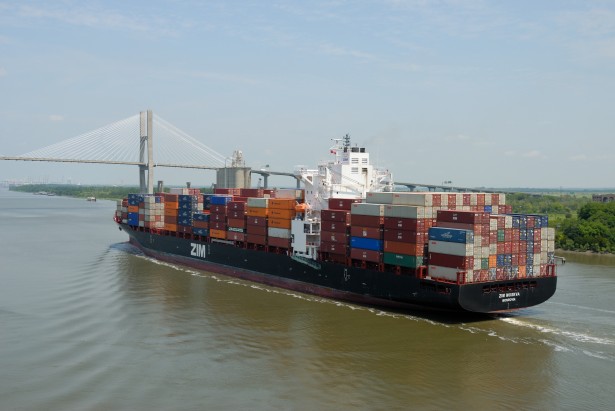
Photo by Paul Brennan 


See Our related Postings of March 9, 2012 and May 4, 2012 on the Economic Health of America's "Jones Act Fleets and Yards" (updated) 

 UPDATES FOR 2016: As we review the end of the first fiscal quarter of 2016 we find the state of the World's merchant fleet not very far different than the below published assessment from 2012. New in recent months of 2015/16 ; some of the World's largest container ships are being idled, some are for sale and a few are reported as candidates for scrapping. The world wide shortage of trained certified, and competent mariners continues to shrink, yet marine wages are not rising. In a world dependent on shipping changes are afoot, but we do see as yet a pattern emerging other than the continued patterns of automation, improvement in the durability of coatings and other technologies, and the related shrinkage in crew size. Some how the shrinkage in both individual ship crew size on average, and the total global fleet size has not yet met the falling supply of trained mariners. Shrinking fuel costs have not improved shipping company profitability sufficiently to make up for falling revenues from shrinking carriage demand and rates. At the end of the first quarter of 2016, ocean shipping continues to simply muddle through.

 Previously in March and earlier in May we reported on the health of America's "Jones Act" or domestic fleets, those American owned and operated fleets that carry waterborne commerce coast wise or via interior waterways between destinations within the United States. We described how America has, since colonial times actually conducted more water borne trade between and among the states than between our nation and all other nations. In both March and May the short term economic indicators for the reserved and protected domestic trades looked promising. We noted then that the major threat to the domestic fleets was the looming labor shortage caused by adverse working conditions. In other postings we described some of these conditions and actions being requested of Congress for corrections. Today we report on the economic health of the world merchant marine, the trans-ocean shipping lines of the various national carriers and the open registry nations from the over all view of a global ocean trade carrying system. The Global system has problems as we head deeper into the second quarter of 2012.

 In a recent article titled U.S.Merchant Marine and World Maritime Review published in the May 2012 issue of the Naval Institutes's PROCEEDINGS (page 94) Capt. Shashi Kumar, Master Mariner, and founding Dean of the Loeb-Sullivan School of Business and International Logistics at Maine Maritime Academy described the "global outlook on shipping" as "somber". In the short term we agree, though like Capt. Kumar we also have to note a few bright spots. 

 As has been the case for a while now, the cruise ship industry in Europe and North America remains strong. The fleet today, if we consider all flags, numbers over 350 vessels carrying in excess of 15 million passengers. Not one of which is seriously using the cruise ship as a means of transport. The ships today are floating resorts that visit other resorts; virtually everyone is on some sort of vacation experience. Nonetheless, these floating hotels are important vessels in emergencies as was demonstrated in the 2005 response to the shortage of housing for emergency relief workers, fire service and police officers in New Orleans after the passage of Hurricane Katrina, or their use by the United States Armed Services in the Middle East during the Second Persian Gulf War as R and R facilities. Their potential as quickly converted hospital ships is obvious. The continued health of this industry sector appears linked to the general health of Western economies and the amount of discretionary income in the hands of the middle and upper middle classes. The health of the cruise ship industry is in marked contrast to the health of bulk commodity and liquid cargo shipping. 

 During the past year the U.S. stock market delisted eight U.S. carriers including the venerable American Commercial Lines, and other well known carriers such as K-Sea Transportation Partners,and  Trailer bridge. Continuing market uncertainties in Europe and elsewhere, and adverse economic pressures generally consisting of rising operating expenses and falling cargo availability and freight rates plagued much of the general cargo industry segment for the last year and the first quarter of 2012 with no real end in sight for the short term.  Globally new ship deliveries in the general cargo segment exceeded trade growth and overall utilization rates for the world combined merchant fleet fell below 84% as reported in the 2012 R.S. Platou data base. The container ship sector fared particularly poorly with nearly one fifth of the fleet severely under utilized. According to the Moore Stephens annual survey the average ship operating cost rose 3.8% in 2011and is expected to double by 2015. Crew wages and the costs of lubricants lead the upward charge in operating costs while fuel costs continue to be almost unpredictable. There has been a general global decline in the asset value of ships and consequently the value of ship owning and operating companies. 

 The bulk commodity sector picked up a bit during the second half of 2012 mostly due to increased demand for iron ore and coal by China. The tanker market was adversely affected by an influx of new ships from mostly Asian yards. In addition to the increased carrying capacity there was a decrease in demand for product due to the mild North American winter. World oil production is increasing as is world oil demand so with some tanker retirements, the tanker market should adjust to more favorable business conditions in the relatively near future. 

 In our two previous reports on Jones Act Fleets and their "Second Tier Shipyards" we reported relatively robust health. However our report was based largely on the performance of the WORKBOAT INDEX of common stocks. We did not notice until the global maritime trade picture began to emerge that the Jones Act fleet's relatively few large ocean transports mostly in the Continental U.S. to Puerto Rico, Alaska, or Hawaii trades had a positive effect on larger American ship yards. New Alaskan crude oil tankers for the Prince William Sound to U.S. West Coast trade helped keep the order books in certain of the larger U.S. ship yards out of the red. Unfortunately the larger vessel Jones Act fleet took a hit in the U.S.-Puerto Rico Jones Act trade where three of four carriers are in trouble and the Commonwealth Government is calling for a review of the effect of the Jones Act on the Puerto Rican economy.

 The World bank has lowered its world wide GDP forecast by about 1.5% while the International Monetary Fund is predicting a significant decline in world trade. Meanwhile new ships continue to enter the market. It appears that the global ocean shipping industry is braced for a long period of adjustment before corporate performance will be able to increase. In such conditions few merchant marines fare as poorly as the United States Merchant Marine which starts with a crew cost rate that is 2.7 times higher than its typical foreign competition. American Admiralty Books continues to point to the importance of the health of the domestic Jones Act sectors as the only viable "reserve" of American Merchant Marine labor, know how, and ship building capacity from which we as a sea faring nation will have any hope of recovery of this aspect of our sea power when favorable market conditions once again return. It is not just the American Merchant Marine that is suffering but all of our competitors as well. Unfortunately we have the least staying power for the large ship trans-ocean trades. If we fall too far we have nothing to build up from except our military sea lift reserves and our Jones Act assets. Our Military sea lift funds are severely constrained and the Jones Act is under attack in the U.S. Senate as we write.


Oceanography and the Marine Environment:

The Arrest of the Sea Shepherd's Master of the STEVE IRWIN


ABC News (Australia) reported today that German maritime authorities had arrested Capt. Paul Watson , Master of the Sea Shepherd owned,  M/V STEVE IRWIN. Capt. Watson is the founder of the marine environmental group "Sea Shepherd", which should not be confused with the more widely known "Green Peace". Green Peace is known for some tactics in defense marine mammals that literally amount to deliberate collisions at sea. Some of their in port protests have created major headaches for vessel traffic authorities, causing one to wonder how tactics that actually increase the danger of a major tanker accident in a crowded port could possibly be in the defense of the environment.Of the two, Sea Shepherd has the better record for common sense and marine safety. It is a disappointment to see Guatemalan and Costa Rican maritime authorities working in concert over what appear to be trumped up charges brought by Guatemalan authorities apparently at the behest of powerful ship owners who were clearly operating outside the law. By contrast, the M/V STEVE IRWIN was actually cooperating with Guatemalan fisheries authorities until some sort of political intervention occurred, or at least is inferred by the subsequent events as reported by ABC (Australia"), Lets examine the "facts" as reported by ABC:
. 
"Paul Watson, the founder of the anti-whaling group Sea Shepherd, has been arrested in Germany and will be extradited to Costa Rica.The activist group has labelled the arrest as "nonsense" and called for the charges against the Canadian-born Watson to be dropped. Sea Shepherd says Watson, who is the captain of the Steve Irwin ship, has been arrested on a Costa Rican warrant over an incident which occurred in 2002. 
"The specific 'violation of ships traffic' incident took place on the high seas in Guatemalan waters, when Sea Shepherd encountered an illegal shark finning operation, run by a Costa Rican ship called the Varadero," the group said in a statement. 
 
"On order of the Guatemalan authorities, Sea Shepherd instructed the crew of the Varadero to cease their illegal shark finning activities and head back to port to be prosecuted." Sea Shepherd claims that while it was taking the Varadero back to port, the tables were turned."A Guatemalan gunboat was dispatched to intercept the Sea Shepherd crew," the group said.
 
"The crew of the Varadero accused Sea Shepherd of trying to kill them, while the video evidence proves this to be a fallacy. "To avoid the Guatemalan gunboat, Sea Shepherd then set sail for Costa Rica, where they uncovered even more illegal shark finning activities in the form of dried shark fins by the thousands on the roofs of industrial buildings."

 American Admiralty Books of course has nothing to go on other that the "facts" as reported by ABC (Australia) reprinted above. Assuming these facts prove accurate something is wrong within both the Guatemalan and Costa Rican fisheries authorities. Assuming the facts are correct, the M/V STEVE IRWIN was doing exactly what  Guatemalan authorities had asked them to do. There was no indication of collision threatening activity. Providing observation and reporting platforms is the safest and probably the most productive conservation enforcement assistance activity that such organizations can do. The activities that the M/V STEVE IRWIN observed and reported on off of Guatemala and in Costa Rica were illegal. Unfortunately, in the space of a few radio messages and obviously some phone calls from politically powerful commercial fishing vessel owners the M/V STEVE IRWIN goes from observer and reporter to the pursued. 

 Clearly the world fisheries resources and ocean environment needs some non governmental watch dogs.We have before us two models of non governmental watch dog tactics, the observe and report  and coordinate with governmental authorities model of the Sea Shepherd activities as reported by ABC (Australia) and the Green Peace model that so often presents environmental and public safety issues of their own. Guatemalan and Costa Rican authorities are exposing themselves to not only possible exposure of corrupt practices before a world audience but also they are suppressing the growth of the more sensible model of non governmental watch dog behavior. It's the sort of behavior displayed by the Guatemalan and Costa Rican authorities that drives the frustrations that drive the far more disruptive and dangerous Green Peace tactics. 
__._,_.___

Friday, May 4, 2012

Oceanography, Naval Interests, Merchant Marine Interests, Sailing:

A FREE VOYAGE PLANNING TOOL AND GUIDE CREATED ESPECIALLY FOR OUR VISITORS  Links updaated 3/21/2019
Photo credit: U.S. Navy

American Admiralty Books Safety & Privacy Policies   EU VISITORS WARNING POSSIBLE COOKIES AHEAD


 One of the American Admiralty Informational Services members who helped originate this blog is an actively sailing officer aboard a scientific research ship. He recently submitted this voyage planning guide and tool from sea where he was actively using it in conjunction with his navigational duties. We hope this is simply the first in a series of  blogs of real navigational utility. In this blog "Cap'n Ben" describes and hyper-  links you to the best sources for weather information, sunrise and sun set calculation ( the first step in computing "star time": if you are navigating celestially), he then introduces the reader to Automatic Identification Systems (AIS) and hyperlinks you to a helpful site. "Cap'n Ben" then takes you to a remarkable site via hyperlink that  may be used to integrate your lap top into your voyage planning / navigational routine with elements like electronic chart overlays, eventually radar overlays, and AIS integration, all free and not difficult to use. "Capn' Ben" originally sent this with actual pictures from the hyper-linked sites. The pictures didn't copy to this format. But we think this tool is so useful that we intend to not just leave it here as a blog but to put the whole thing hopefully with illustrations in the Oceanography section, Navigation section, or eventually in a special page titled "Ben's tech spot" with cross references to other sections with navigational interests where "Cap'n Ben" can update and improve the tools he creates for you as time and technology change with the tides. While you're collecting "Cap'n Ben" laptop navigational tools, drop into the Oceanography section and look for "The Exclusive economic Zone (EEZ) and the Rights of Innocent Passage" There you will learn of some of the political complications involved in voyage planning when your ship must cross a coastal nations Exclusive economic zone (EEZ). You will also be able to use another "Cap,n Ben contribution a hyperlink to a site where you can see in navigational chart form the World's EEZs and disputed zones.

   If you have any problem with the hyperlinks please let us know via the Comments section, the editor on duty today is an old gnarled and grizzled Boatswains mate known for fat fingered and ham handed key stroking. If the links didn't come through we'll sober up the regular guy and get him on it by Monday, but we really wanted our actively navigating visitors to see this ASAP.  Welcome to:


Ben's Tech Spot
Ever notice how some things in the Maritime Technology world advance at a lightening pace while others are locked in a time capsule? A perfect example is some Global Maritime Distress and Safety System (GMDSS) equipment still runs on DOS based software. DOS is a software system from the 80s! Remember having to type commands in command windows before the time of point and clicking with a mouse! While some aspects of Maritime Technology have been locked in time or are released years after the shore side equivalents are released to the public, there are some cool new tech tools that every mariner can take advantage of.

 Internet at sea is becoming more and more available for both day sailors and the professional mariner alike. Internet at sea brings with it a whole slew of new and exciting tools that can help with planning, safety, navigation, weather, and communication. Many near coastal sailors are now able to simply tether their smart phone to a laptop and get real time weather updates, check vessel traffic, and even broadcast their AIS or positional information to free traffic servers so shore side family and friends can keep track of them along their voyage.Many links in today's blog are my short list of new cool technology and resources as well as some tried and true links that every mariner should know. Even if you aren't able to surf the web at sea, many of these links are great planning tools and software that can be used underway regardless of web access or not.

Weather
Most Mariners are familiar with NOAAs weather forecasts available on most marine radios or many go to www.weather.gov to get NOAAs near shore and off shore forecasts. NOAA has some other great links that aren't as well know.
National Data Bouy Center's Interactive Buoy Map
NDBC has an interactive Google Earth Map that has real-time information from a world wide array of meteorological buoys. Simply find a buoy, click on it, and get real-time info about wave height, wind speed and direction, sea and air temp etc. It's a great tool to compare what the forecasters predicted and what is really happening along your route or at your destination.
NOAA Current Forecasts
For worldwide current forecasts point your browser to the above address. This is another great tool for voyage planning. Want to take advantage of the loop current or avoid it, simply take a look at the current models for the region you will be sailing in.

Just as we should never rely on any one form of navigation alone, never put all weather forecasting faith in any one group or forecaster. Here are some other great weather forecasting sites to use and compare.

Weather Underground
A great site that is good to use for their Sever Weather section. During hurricane season, check out the "Compiled Model". Usually a hurricane forecast is the average of a bunch of different models that forecasters have developed over the years. They usually will average these or pick the route that most of the models seem to follow to use in their hurricane track forecast. Wunderground's compiled model lets you do the averaging by showing you all the major models prediction of the storm path.
Storm Surf
A forecasting site that was originally designed and used by surfers. In some parts of the world these forecasts have proven to be more accurate than local models. Easily find wind, surf, and sea forecasts for select regions of the world. A must have site for any surfers out there.
SailWX
SailWX is a great little site that has real-time meteorological observations from ships all over the world. Any ship that is a member of the Voluntarily Observing Ship (VOS) program is listed on the site. While the interactive map isn't as user friendly as some of the other sites it is still fairly easy to navigate. Simply click on a ship on the map to get real time observations for any meteorological readings the ship is reporting. The site is a great little "Ship Tracker" site that has a very high number of ships participating. Chances are if you're on a cruise ship, oceanographic ship, tall ship, or container/cargo ship, you're on the map. The site also has tide and current predictions.


Sunrise/Sunset Calculator
Google Map page that provides Sunrise Sunset calculations for any point on earth. Simply click on a spot on the map and get your calculations.
XM Weather
For anyone wanting real-time weather information and forecasts but don't have a weather fax or internet at sea, SiriusXM has the product for you. XM WX Marine Weather is a program that uses the XM Sirius Satellite system to broadcast weather products to your laptop. Coverage is for the majority of US waters. I'll provide a more detailed review of the Master Mariner version of the program later.

Automatic Identification System (AIS)
AIS is a technology that has propelled the bridge of ship's light years ahead. AIS is an automatic tracking system used by ships and vessel traffic systems for reporting a vessels identification and basic navigational information. It's a standard used throughout the world on vessels 300 GT and greater. Many smaller vessels have been equipped with AIS transceivers as well due to its benefits. The cost of AIS has come down considerably. As anyone who sails with AIS know it makes instantaneous identification of other vessels a breeze. Simple turn on your AIS overlay on your basic navigation software and you instantly see all reporting vessels around you. You can quickly get their name, navigation status, position, course, speed, as well as basic voyage information. Most navigation programs are able to overlay AIS contacts directly on the chart.
Since AIS information is free and can be received by anyone with a receiver there has been a push to unify and establish an online AIS system available to all for free. A few sites have tried to do this. One that seems to be way out front is http://www.marinetraffic.com This website uses a Google Earth map to display a large world wide database of real-time AIS information. Basically anyone with an internet connection and an AIS receiver can submit their data to a central server that Marine Traffic then uses. Marine Traffic has by far the largest network of receivers all over the world. It's nothing for the site to be tracking over 50,000 AIS contacts at one time throughout the entire world! The site does a great job of displaying them and making them interactive.
You can simply click on a ship on the map and get its most current information as well as see pictures of the vessel. Marine Traffic has one of the largest collections of ship photos I have seen. Most appear to have been uploaded by the general public.


Marine Traffic also lets you embed their AIS map directly into your webpage, has mobile apps for both iPhone and Android, as well as a really nice Google Earth overlay kml. Anyone with that wants to set up a base station can follow the directions on their site and begin adding to the overall coverage. There are even instructions on how to build an AIS receiver using a old marine radio!

OpenCPN
Is a great free open source navigation program that is by far the best on the market today. A quick google of "Free navigational program" quickly shows you the lack of programs out there that are really free. Most of the free ones out there are old and outdated as well as fairly buggy. OpenCPN has a great following and its open source code allows for others to develop addons. So the feature possibilities are fairly limitless. It already has AIS integration and can even accept a networked GPS feed. It can display both Raster and ENC Vector charts, is light weight, quick, and clean. Developers are currently working on a radar overlay function as well. Why spend hundreds on the name brand software packages when OpenCPN does almost everything they can for free.


Oceanography, Naval Interests, Merchant Marine Interests, Sailing:

A FREE VOYAGE PLANNING TOOL AND GUIDE CREATED ESPECIALLY FOR OUR VISITORS  Links Checked 2/23/2015
Photo credit: U.S. Navy

American Admiralty Books Safety & Privacy Policies   EU VISITORS WARNING POSSIBLE COOKIES AHEAD


 One of the American Admiralty Informational Services members who helped originate this blog is an actively sailing officer aboard a scientific research ship. He recently submitted this voyage planning guide and tool from sea where he was actively using it in conjunction with his navigational duties. We hope this is simply the first in a series of  blogs of real navigational utility. In this blog "Cap'n Ben" describes and hyper-  links you to the best sources for weather information, sunrise and sun set calculation ( the first step in computing "star time": if you are navigating celestially), he then introduces the reader to Automatic Identification Systems (AIS) and hyperlinks you to a helpful site. "Cap'n Ben" then takes you to a remarkable site via hyperlink that  may be used to integrate your lap top into your voyage planning / navigational routine with elements like electronic chart overlays, eventually radar overlays, and AIS integration, all free and not difficult to use. "Capn' Ben" originally sent this with actual pictures from the hyper-linked sites. The pictures didn't copy to this format. But we think this tool is so useful that we intend to not just leave it here as a blog but to put the whole thing hopefully with illustrations in the Oceanography section, Navigation section, or eventually in a special page titled "Ben's tech spot" with cross references to other sections with navigational interests where "Cap'n Ben" can update and improve the tools he creates for you as time and technology change with the tides. While you're collecting "Cap'n Ben" laptop navigational tools, drop into the Oceanography section and look for "The Exclusive economic Zone (EEZ) and the Rights of Innocent Passage" There you will learn of some of the political complications involved in voyage planning when your ship must cross a coastal nations Exclusive economic zone (EEZ). You will also be able to use another "Cap,n Ben contribution a hyperlink to a site where you can see in navigational chart form the World's EEZs and disputed zones.

   If you have any problem with the hyperlinks please let us know via the Comments section, the editor on duty today is an old gnarled and grizzled Boatswains mate known for fat fingered and ham handed key stroking. If the links didn't come through we'll sober up the regular guy and get him on it by Monday, but we really wanted our actively navigating visitors to see this ASAP.  Welcome to:


Ben's Tech Spot
Ever notice how some things in the Maritime Technology world advance at a lightening pace while others are locked in a time capsule? A perfect example is some Global Maritime Distress and Safety System (GMDSS) equipment still runs on DOS based software. DOS is a software system from the 80s! Remember having to type commands in command windows before the time of point and clicking with a mouse! While some aspects of Maritime Technology have been locked in time or are released years after the shore side equivalents are released to the public, there are some cool new tech tools that every mariner can take advantage of.

 Internet at sea is becoming more and more available for both day sailors and the professional mariner alike. Internet at sea brings with it a whole slew of new and exciting tools that can help with planning, safety, navigation, weather, and communication. Many near coastal sailors are now able to simply tether their smart phone to a laptop and get real time weather updates, check vessel traffic, and even broadcast their AIS or positional information to free traffic servers so shore side family and friends can keep track of them along their voyage.Many links in today's blog are my short list of new cool technology and resources as well as some tried and true links that every mariner should know. Even if you aren't able to surf the web at sea, many of these links are great planning tools and software that can be used underway regardless of web access or not.

Weather
Most Mariners are familiar with NOAAs weather forecasts available on most marine radios or many go to www.weather.gov to get NOAAs near shore and off shore forecasts. NOAA has some other great links that aren't as well know.
National Data Bouy Center's Interactive Buoy Map
NDBC has an interactive Google Earth Map that has real-time information from a world wide array of meteorological buoys. Simply find a buoy, click on it, and get real-time info about wave height, wind speed and direction, sea and air temp etc. It's a great tool to compare what the forecasters predicted and what is really happening along your route or at your destination.
NOAA Current Forecasts
For worldwide current forecasts point your browser to the above address. This is another great tool for voyage planning. Want to take advantage of the loop current or avoid it, simply take a look at the current models for the region you will be sailing in.

Just as we should never rely on any one form of navigation alone, never put all weather forecasting faith in any one group or forecaster. Here are some other great weather forecasting sites to use and compare.

Weather Underground
A great site that is good to use for their Sever Weather section. During hurricane season, check out the "Compiled Model". Usually a hurricane forecast is the average of a bunch of different models that forecasters have developed over the years. They usually will average these or pick the route that most of the models seem to follow to use in their hurricane track forecast. Wunderground's compiled model lets you do the averaging by showing you all the major models prediction of the storm path.
Storm Surf
A forecasting site that was originally designed and used by surfers. In some parts of the world these forecasts have proven to be more accurate than local models. Easily find wind, surf, and sea forecasts for select regions of the world. A must have site for any surfers out there.
SailWX
SailWX is a great little site that has real-time meteorological observations from ships all over the world. Any ship that is a member of the Voluntarily Observing Ship (VOS) program is listed on the site. While the interactive map isn't as user friendly as some of the other sites it is still fairly easy to navigate. Simply click on a ship on the map to get real time observations for any meteorological readings the ship is reporting. The site is a great little "Ship Tracker" site that has a very high number of ships participating. Chances are if you're on a cruise ship, oceanographic ship, tall ship, or container/cargo ship, you're on the map. The site also has tide and current predictions.


Sunrise/Sunset Calculator
Google Map page that provides Sunrise Sunset calculations for any point on earth. Simply click on a spot on the map and get your calculations.
XM Weather
For anyone wanting real-time weather information and forecasts but don't have a weather fax or internet at sea, SiriusXM has the product for you. XM WX Marine Weather is a program that uses the XM Sirius Satellite system to broadcast weather products to your laptop. Coverage is for the majority of US waters. I'll provide a more detailed review of the Master Mariner version of the program later.

Automatic Identification System (AIS)
AIS is a technology that has propelled the bridge of ship's light years ahead. AIS is an automatic tracking system used by ships and vessel traffic systems for reporting a vessels identification and basic navigational information. It's a standard used throughout the world on vessels 300 GT and greater. Many smaller vessels have been equipped with AIS transceivers as well due to its benefits. The cost of AIS has come down considerably. As anyone who sails with AIS know it makes instantaneous identification of other vessels a breeze. Simple turn on your AIS overlay on your basic navigation software and you instantly see all reporting vessels around you. You can quickly get their name, navigation status, position, course, speed, as well as basic voyage information. Most navigation programs are able to overlay AIS contacts directly on the chart.
Since AIS information is free and can be received by anyone with a receiver there has been a push to unify and establish an online AIS system available to all for free. A few sites have tried to do this. One that seems to be way out front is http://www.marinetraffic.com This website uses a Google Earth map to display a large world wide database of real-time AIS information. Basically anyone with an internet connection and an AIS receiver can submit their data to a central server that Marine Traffic then uses. Marine Traffic has by far the largest network of receivers all over the world. It's nothing for the site to be tracking over 50,000 AIS contacts at one time throughout the entire world! The site does a great job of displaying them and making them interactive.
You can simply click on a ship on the map and get its most current information as well as see pictures of the vessel. Marine Traffic has one of the largest collections of ship photos I have seen. Most appear to have been uploaded by the general public.


Marine Traffic also lets you embed their AIS map directly into your webpage, has mobile apps for both iPhone and Android, as well as a really nice Google Earth overlay kml. Anyone with that wants to set up a base station can follow the directions on their site and begin adding to the overall coverage. There are even instructions on how to build an AIS receiver using a old marine radio!

OpenCPN
Is a great free open source navigation program that is by far the best on the market today. A quick google of "Free navigational program" quickly shows you the lack of programs out there that are really free. Most of the free ones out there are old and outdated as well as fairly buggy. OpenCPN has a great following and its open source code allows for others to develop addons. So the feature possibilities are fairly limitless. It already has AIS integration and can even accept a networked GPS feed. It can display both Raster and ENC Vector charts, is light weight, quick, and clean. Developers are currently working on a radar overlay function as well. Why spend hundreds on the name brand software packages when OpenCPN does almost everything they can for free.


Oceanography, Naval Interests, Merchant Marine Interests, Sailing:

A FREE VOYAGE PLANNING TOOL AND GUIDE CREATED ESPECIALLY FOR OUR VISITORS  Links Checked 2/23/2015
Photo credit: U.S. Navy

American Admiralty Books Safety & Privacy Policies   EU VISITORS WARNING POSSIBLE COOKIES AHEAD


 One of the American Admiralty Informational Services members who helped originate this blog is an actively sailing officer aboard a scientific research ship. He recently submitted this voyage planning guide and tool from sea where he was actively using it in conjunction with his navigational duties. We hope this is simply the first in a series of  blogs of real navigational utility. In this blog "Cap'n Ben" describes and hyper-  links you to the best sources for weather information, sunrise and sun set calculation ( the first step in computing "star time": if you are navigating celestially), he then introduces the reader to Automatic Identification Systems (AIS) and hyperlinks you to a helpful site. "Cap'n Ben" then takes you to a remarkable site via hyperlink that  may be used to integrate your lap top into your voyage planning / navigational routine with elements like electronic chart overlays, eventually radar overlays, and AIS integration, all free and not difficult to use. "Capn' Ben" originally sent this with actual pictures from the hyper-linked sites. The pictures didn't copy to this format. But we think this tool is so useful that we intend to not just leave it here as a blog but to put the whole thing hopefully with illustrations in the Oceanography section, Navigation section, or eventually in a special page titled "Ben's tech spot" with cross references to other sections with navigational interests where "Cap'n Ben" can update and improve the tools he creates for you as time and technology change with the tides. While you're collecting "Cap'n Ben" laptop navigational tools, drop into the Oceanography section and look for "The Exclusive economic Zone (EEZ) and the Rights of Innocent Passage" There you will learn of some of the political complications involved in voyage planning when your ship must cross a coastal nations Exclusive economic zone (EEZ). You will also be able to use another "Cap,n Ben contribution a hyperlink to a site where you can see in navigational chart form the World's EEZs and disputed zones.

   If you have any problem with the hyperlinks please let us know via the Comments section, the editor on duty today is an old gnarled and grizzled Boatswains mate known for fat fingered and ham handed key stroking. If the links didn't come through we'll sober up the regular guy and get him on it by Monday, but we really wanted our actively navigating visitors to see this ASAP.  Welcome to:


Ben's Tech Spot
Ever notice how some things in the Maritime Technology world advance at a lightening pace while others are locked in a time capsule? A perfect example is some Global Maritime Distress and Safety System (GMDSS) equipment still runs on DOS based software. DOS is a software system from the 80s! Remember having to type commands in command windows before the time of point and clicking with a mouse! While some aspects of Maritime Technology have been locked in time or are released years after the shore side equivalents are released to the public, there are some cool new tech tools that every mariner can take advantage of.

 Internet at sea is becoming more and more available for both day sailors and the professional mariner alike. Internet at sea brings with it a whole slew of new and exciting tools that can help with planning, safety, navigation, weather, and communication. Many near coastal sailors are now able to simply tether their smart phone to a laptop and get real time weather updates, check vessel traffic, and even broadcast their AIS or positional information to free traffic servers so shore side family and friends can keep track of them along their voyage.Many links in today's blog are my short list of new cool technology and resources as well as some tried and true links that every mariner should know. Even if you aren't able to surf the web at sea, many of these links are great planning tools and software that can be used underway regardless of web access or not.

Weather
Most Mariners are familiar with NOAAs weather forecasts available on most marine radios or many go to www.weather.gov to get NOAAs near shore and off shore forecasts. NOAA has some other great links that aren't as well know.
National Data Bouy Center's Interactive Buoy Map
NDBC has an interactive Google Earth Map that has real-time information from a world wide array of meteorological buoys. Simply find a buoy, click on it, and get real-time info about wave height, wind speed and direction, sea and air temp etc. It's a great tool to compare what the forecasters predicted and what is really happening along your route or at your destination.
NOAA Current Forecasts
For worldwide current forecasts point your browser to the above address. This is another great tool for voyage planning. Want to take advantage of the loop current or avoid it, simply take a look at the current models for the region you will be sailing in.

Just as we should never rely on any one form of navigation alone, never put all weather forecasting faith in any one group or forecaster. Here are some other great weather forecasting sites to use and compare.

Weather Underground
A great site that is good to use for their Sever Weather section. During hurricane season, check out the "Compiled Model". Usually a hurricane forecast is the average of a bunch of different models that forecasters have developed over the years. They usually will average these or pick the route that most of the models seem to follow to use in their hurricane track forecast. Wunderground's compiled model lets you do the averaging by showing you all the major models prediction of the storm path.
Storm Surf
A forecasting site that was originally designed and used by surfers. In some parts of the world these forecasts have proven to be more accurate than local models. Easily find wind, surf, and sea forecasts for select regions of the world. A must have site for any surfers out there.
SailWX
SailWX is a great little site that has real-time meteorological observations from ships all over the world. Any ship that is a member of the Voluntarily Observing Ship (VOS) program is listed on the site. While the interactive map isn't as user friendly as some of the other sites it is still fairly easy to navigate. Simply click on a ship on the map to get real time observations for any meteorological readings the ship is reporting. The site is a great little "Ship Tracker" site that has a very high number of ships participating. Chances are if you're on a cruise ship, oceanographic ship, tall ship, or container/cargo ship, you're on the map. The site also has tide and current predictions.


Sunrise/Sunset Calculator
Google Map page that provides Sunrise Sunset calculations for any point on earth. Simply click on a spot on the map and get your calculations.
XM Weather
For anyone wanting real-time weather information and forecasts but don't have a weather fax or internet at sea, SiriusXM has the product for you. XM WX Marine Weather is a program that uses the XM Sirius Satellite system to broadcast weather products to your laptop. Coverage is for the majority of US waters. I'll provide a more detailed review of the Master Mariner version of the program later.

Automatic Identification System (AIS)
AIS is a technology that has propelled the bridge of ship's light years ahead. AIS is an automatic tracking system used by ships and vessel traffic systems for reporting a vessels identification and basic navigational information. It's a standard used throughout the world on vessels 300 GT and greater. Many smaller vessels have been equipped with AIS transceivers as well due to its benefits. The cost of AIS has come down considerably. As anyone who sails with AIS know it makes instantaneous identification of other vessels a breeze. Simple turn on your AIS overlay on your basic navigation software and you instantly see all reporting vessels around you. You can quickly get their name, navigation status, position, course, speed, as well as basic voyage information. Most navigation programs are able to overlay AIS contacts directly on the chart.
Since AIS information is free and can be received by anyone with a receiver there has been a push to unify and establish an online AIS system available to all for free. A few sites have tried to do this. One that seems to be way out front is http://www.marinetraffic.com This website uses a Google Earth map to display a large world wide database of real-time AIS information. Basically anyone with an internet connection and an AIS receiver can submit their data to a central server that Marine Traffic then uses. Marine Traffic has by far the largest network of receivers all over the world. It's nothing for the site to be tracking over 50,000 AIS contacts at one time throughout the entire world! The site does a great job of displaying them and making them interactive.
You can simply click on a ship on the map and get its most current information as well as see pictures of the vessel. Marine Traffic has one of the largest collections of ship photos I have seen. Most appear to have been uploaded by the general public.


Marine Traffic also lets you embed their AIS map directly into your webpage, has mobile apps for both iPhone and Android, as well as a really nice Google Earth overlay kml. Anyone with that wants to set up a base station can follow the directions on their site and begin adding to the overall coverage. There are even instructions on how to build an AIS receiver using a old marine radio!

OpenCPN
Is a great free open source navigation program that is by far the best on the market today. A quick google of "Free navigational program" quickly shows you the lack of programs out there that are really free. Most of the free ones out there are old and outdated as well as fairly buggy. OpenCPN has a great following and its open source code allows for others to develop addons. So the feature possibilities are fairly limitless. It already has AIS integration and can even accept a networked GPS feed. It can display both Raster and ENC Vector charts, is light weight, quick, and clean. Developers are currently working on a radar overlay function as well. Why spend hundreds on the name brand software packages when OpenCPN does almost everything they can for free.


Merchant Marine Interests:

THE ECONOMIC HEALTH OF THE JONE'S ACT FLEETS AND YARDS


American Admiralty Books Safety & Privacy Policies   EU VISITORS WARNING POSSIBLE COOKIES AHEAD

Image : US Army Corps of Engineers
Posted: May 4, 2012
Report No. 2, last report March 9, 2012
Updated 3/11/2016

 The "Jones Act Fleet" refers to the commercial vessels registered in the United States and manned by, or at least officered by Coast Guard documented members of the United States Merchant Marine and providing transportation and other services on our near coastal and interior waters . Typically the fleet includes tugs, towboats, barges, off shore service and support vessels, the Great Lakes grain and iron ore boats, ferries, dredges, excursion boats and a variety of other vessels. All totaled this fleet employs over 126,000 American merchant mariners and an uncounted number of personnel not documented by the U.S. Coast Guard in the inland towing trades below the level of licensed officer or certified tankerman. For a more complete description of the Jones Act fleets and yards and their economic and security importance to America see our first report on this subject dated March 9, 2012. The latest available information on the economic health of this fleet is up to date through February 2012. 

 The slow recovery of drilling activity in the U.S. Gulf in the wake of the British Petroleum disaster continues slow but relatively steady. WORKBOAT MAGAZINE 's April 2012 issue reported a 6% gain for work boat operators whose stock the magazine tracks as part of their "WORKBOAT  COMPOSITE INDEX". This recent (2012) 6% gain is part of an overall rise of 79 points in the "WORKBOAT COMPOSITE INDEX" of commercial work vessel operating, supply, and boat building companies since our last report. According to the April "WORKBOAT " The overall Composite Index rose 182 points in January.  For the month of January Workboat Composite Index stocks had "winners" out numbering "losers" by a ratio of more than 2 to 1. Update 3/11/2016 the offshore oil industry support vessel fleet is undergoing a period of idled vessels , shrinking revenues from both shortages of charter contracts and shrinkage of day rates as a result of the shrinking price of oil. Recent US discoveries on land particularly large shale oil finds have made offshore oil expensive by comparison and uneconomic in many cases given the total amount of oil on present markets. The WORKBOAT COMPOSITE INDEX IS PUBLISHED MONTHLY IN WORKBOAT MAGAZINE 

 Vessel operators were not the only "winners"in 2012. The supplier's index gained 5.7% and the "second tier" shipyards in the index rose 5.4%. Complete details on the performance of the Workboat Composite Index may be found on page 12 of the April 2012 issue of WORKBOAT. We have a hyperlink to the WORKBOAT website and information on how to obtain a free subscription in the "Merchant Marine Interest"section. By 2016 we see a fall in stock prices across the board in the index as the towing industry remains somewhat static, the offshore support vessel industry shrinks, and only the excursion boat and ferry sectors appear healthy.

 The Philadelphia Oil Service Index tracks some stocks that are redundant with certain of the Workboat Composite Index stocks but is more focused on oil exploration and production, major economic drivers of the offshore service and supply vessel industry and a major cargo source for the inland towing industry. The Philadelphia Oil Service Index may at times be something of the canary in the miner's cage for parts of the Jones Act fleets. Fortunately, at present, the index indicates a pretty healthy canary. The Philadelphia Oil Service Index gained 17 points on a slow but steady rise in the post BP oil disaster market that is now 9 points above its close of 245.12 in 2010. In 2016 this index like the WORKBOAT COMPOSITE INDEX does not show much in the way of promise for our Jones Act fleets. 

 The towboat and barge sectors are are predicted to have a good year for the export grain trade (2012). While U.S. harvests of late have averaged a bit below forecasts , the existing world inventories are relatively low. Foreign drought conditions have reduced this year's competitive pressures by nearly 25%. Grain cargo availability is is up while the excessive covered  hopper barge capacity of the past has been reduced. Hopper barge availability has been described this year as "tight", while grain prices are rising. It is difficult for us to imagine a better combination for profitable "ton mile" freight rates for grain. In 2016 ton mile rates for grain carriage remain favorable but there is no over all boost to the system since 2012, the towing sector is stable at best, exclusive of the offshore support segment within the towing sector.

 Another large cargo provider for the towboat and barge industry, particularly for open hopper barges  is coal. Domestic coal burns declined over the winter due to mild weather in the Eastern U.S.. Export coal is booming and a new cargo is appearing. Shale gas production fueled by the Marcellus shale gas boom is generating cargoes suitable for open hopper and deck barges related to the hydraulic fracturing and horizontal drilling required to extract natural gas contained in shale formations. Ton mile rates for open hopper and deck barges remain profitable and appear to be improving. In 2015/16 both mild winters continued as well as the trend towards the Marcellus shale gas boom. Unfortunately, gas can not be acrried in open hopper barges, so accommodating the transition requires more construction of expensive tank barges. One fleet of barges is being reduced while another is coming into being, while the number of towing vessels employed remains rather steady, a formula for static profits.

 In the tank barge sector heating oil consumption was down due to mild winter weather, gasoline, aviation fuels, and chemical transport volumes for the winter were apparently unremarkable. Despite the slow start to the year for the tank barge sector deliveries of inland tank barges certified for red flag cargoes reached 165 at the close of 2011. Transportation demand for crude oil being generated out of new fields in the Midwest are generating new south bound liquid cargoes that have more than made up for the reduction in north bound refined products due to the mild winter. Again these trends continued through the first quarter of 2016 to a large extent.

 Many of the "second tier" ship yards that service the Jones Act trades are doing well, especially barge builders. At the close of business in 2011; 165 inland tank barges had been delivered with more on the ways as 2012 opened. This is up about 49 hulls over the 2010. At close of Business for 2011 hopper barge construction was up 10% over the previous years with more hulls still on the way and many builders reporting decent starts in the first quarter for their order books. Tank barge giant Kirby Corp of Houston announced record net earnings for the fourth quarter of 2011 of $56.2 million or $1 per share, compared with #31.6 million , or 59 cents per share the year earlier period. The second tier ship yards are not doing as well in 2016 but barge construction continues, along with excursion, ferry, public service ( often fire boats ) hulls. SOme yards profit briefly from increased lay up work for idled offshore vessels but over all stock prices for many of the publicly traded second tier yards were down from 2012 levels. 

 For the offshore service vessel sector day rates and utilization rates were a mixed bag in February 0f 2012.  The larger supply vessels or "deep water" units reported an average day rate increase for February of $1,900 and a 1% increase in utilization rate. Large crew boats which compete not only with the passenger capacity of supply vessels but also with helicopters for the crew change trade experienced a $220 drop in the day rate and a drop in utilization of about 1%. More new drilling vessels are arriving on the Gulf Coast in response to the resumption of deep water permitting and these will require service vessel support.The Interior Department has reported a decrease in the review time for new drilling permits. This is also a positive indicator of future increased demand for offshore service and supply vessels. We were wrong in 2012. While there were the indications described and while such usually indicate future demand, we did not see the global oil glut, and its effect on the offshore industry. In the first quarter of 2016 the offshore service vessel sector continues to experienced reduced demand.

 The overnight cruise trade is returning to the rivers after the post 9/11 loss of the Delta Queen steamboat company. The Queen of the Mississippi is nearing construction at Chesapeake Shipbuilding in Salisbury, Maryland. Its inaugural cruise will be in August from New Orleans to Memphis. American Cruise lines is beginning to fill the void left by the venerable Delta Queen line. America's reluctance to engage in recreational air travel due to the annoying security requirements continues to negatively impact inland passenger trades both for overnight and day excursion services but overall the industry is coming back from the worst days after "9/11". In 2015 news was received of a venture to return the venerable DELTA QUEEN to overnight service on the rivers, at this writing she is undergoing renovations in a Louisiana yard.

 Our conclusion (for 2012) was updated from our guardedly optimistic conclusion of March 9th. With the 2011 year end data in and the first two months of the first quarter complete, the out look for the Jones Act Sector for the remainder of 2012 appeared good with recoveries where needed finishing out that year, and real growth in several sectors. But we cautioned then that no one should make investment decisions on our analysis. We track and report on this sector for a variety of reasons none of which involve investment. Our 2016 analysis is not promising in the short term and as we have reported elsewhere Sen. John McCain and the usual suspects are busy again this season (2016) attempting to destroy the Jones Act. We will continue to track and report economic conditions in the Jones Act industries through out the year because things change and we don't trust our crystal ball , only God can really see the future and trend is often not future.

U.S.Merchant Marine Shop Hats, Shirts, Jackets, Watches, Jewelry, Decorations, Etc.
Product DetailsProduct DetailsProduct Details

Tuesday, May 1, 2012

Naval Interest: Up date 2/10/2015

Sailors, Marines, Guardians, 

GET A GRIP ON THOSE "I PHONES"

Sailors & Media Observe Ghost Swimmer Vehicle Test. Photo by  Mass Communication Specialist 3rd Class Edward Guttierrez III.

"Loose Lips Sink Ships", Loose I Phones Have Now Destroyed Aircraft

Editor's note: We ran this several years ago, as far as we can tell by reports of similar incidents there have been some serious communications security improvements since. But this a story and advice worth repeating periodically. 

American Admiralty Books Safety & Privacy Policies   EU VISITORS WARNING POSSIBLE COOKIES AHEAD


 We wish that all members of the Navy, Marine Corps, Coast Guard, and Merchant Marine were members of  the U.S.Naval Institute and avid readers of their monthly PROCEEDINGS. Unfortunately we are all too aware that this is not the case. Frequently the PROCEEDINGS carries maritime news of national consequence entirely missed by the national media. The May 2012 issue carries a story titled "Technology's Hidden Dangers" by frequent contributor Norman Friedman on page 162. In this article Mr. Friedman recounts a recent under reported event in Afghanistan. As reported in the article four new attack helicopters were delivered to a U.S. base, the location of which had apparently been unknown to the Taliban. Military personnel photographed the technologically advanced air craft and posted the pictures on the Internet. The air craft frames apparently were not "classified". A short time after the pictures were posted the Taliban destroyed the air craft in a mortar attack.

 Apparently the service members had used smart phones to take the pictures. Smart phones generally incorporate GPS receivers and they automatically tag their photos with GPS locations. As a veteran of active duty in the days before personal computers/ smart phones , I have a deep appreciation of the morale benefit to our troops of these devices. Military journals are full of stories where these personal devices have proven to be of benefit in emergency and even combat situations for our service members. I certainly don't want to see their use curtailed. However all service members need to seriously consider the near complete lack of privacy on the Internet and curb their I phone and other Internet usage accordingly.

 As the case described in this month's PROCEEDINGS  article illustrates merely abstaining from photographing or discussing classified information is not enough. Communications security is vital in combat and law enforcement operations and there is a lot of unclassified but none the less critical information out there. We hope all of our naval interest readers who are in uniform, or accompanying those who are in uniform into the field or fleets, will consider the following suggestions:

 1. Never use your I phone in combat unless you are already under fire and for some reason it becomes your only way to call for back up.

2. Don't discuss ship movements, base locations, equipment arrivals' or anything else remotely thought to be "sensitive" even if not "classified" on any wireless medium except DOD provided secure sources' and then only if it is part of your job to do so. When in doubt consider the information "sensitive".

3. Buy a digital camera and restrict the building of your military career photo album to a camera only camera and avoid the use of your I phone camera under any sensitive circumstances .Print your pictures and surface mail photos to family if your photos contain any on base, or on ship scenes unless those ship scenes are pretty old and can't give away the ship's position any longer (remember the automatic GPS tagging feature). 
If you routinely used surface mail your pictures always would be a bit aged and it would be much harder for anyone to compromise any inadvertently sensitive information associated with them.

4. Always consider the Internet and all wireless means of communication as an "insecure" method of communications even if using an encrypted program. 

5. Commanding officers should consider designating a photographer for certain events that the troops would consider worthy of special remembrance but taking place where some sensitive information may be in view, and carefully review and time the release of these photos to the troops while prohibiting the use of private cameras in such areas.   

6. Personal communications security is every one's job, don't let it become no one's job. What is at stake is not only force security but the continued wide spread availability of modern personal communications technology to our deployed troops. Commanding Officers, Executive Officers, Command Master Chiefs and Command Sargent Majors should take the lead in educating the crew and troops to the issue. The continued availability of personal and instant communications with the family are a critical aspect of modern deployment. But if the technology can not be controlled operational security will ultimately require restricted access.