Editor's note 2/15/2015 We first ran this report a couple of years ago. We are pleased to report that there has been no repeat as lessons learned have been applied by the American pilot corps serving Jones Act shipping. We repeat the report because Senator John McCain is again sponsoring legislation that would eliminate the Jones Act. Does anyone think our domestic waters will be safer under Mexican Merchant Marine Officers? Retire McCain.
This accident which we reported on last winter is an example of a Jones Act voyage that Senator McCaine would entrust to foreigners. Our own American crew made a big mistake here and we blame it in part on a loop hole in the Jones Act fleet regulations. The National Mariners Association has asked Congress to address the needed changes. When Mexicans are piloting these operations who will be lobbying Congress to improve safety regulations. American pilots aren't perfect but will foreigners on our waters be better? And how will we employ the tens of thousands of Americans put out of work by Senator McCain's proposal? Click on the blue link below for photos and story of a ship movement gone wrong ........in Kentucky.
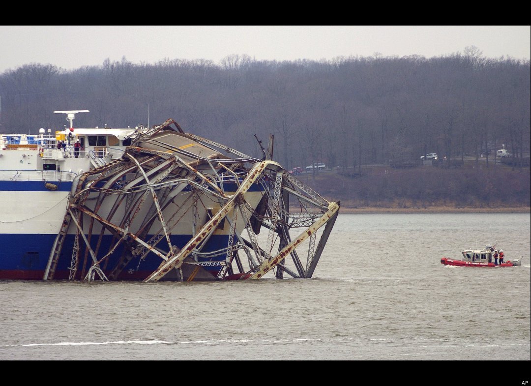 |
| Photo of Rocket Carrier DELTA MARINER and Coast Guard Response Boat after the DELTA MARINER hit a Kentucky bridge. Photo is from the linked account by the Huffington Post |
Eggner Ferry Bridge Hit By Delta Mariner Ship In Kentucky (PHOTOS)
The hyperlink associated with this blog posting will take you to a full Internet account of today's "bridge allision" in Kentucky where a "ship" hit a bridge and took out the main span. The "ship" DELTA MARINER is an actual ship in the sense of the word of having real ocean transport capability and indeed entered the river navigation system from sea. Most non-maritime professionals, at best are aware of towboat and barge traffic on our inland rivers, but few people expect to see ocean going ships operating on Kentucky waters. So we thought that we'd take this opportunity to explain a few unique aspects of our inland merchant marine, and introduce our readers to some unique nautical vocabulary, especially if you are a non-maritime professional visitor to our humble site.
The DELTA MARINER is a "ship" of about 8,000 plus "gross registered tons." By contrast, typical bulk carriers or container ships calling at New Orleans from sea and unable to navigate higher up the Mississippi than Baton Rouge would be of about 50,000, to in excess of 100,000 "Gross registered tons." This should give you some idea of the relative size of the of the DELTA MARINER. She is a sort of "mini ship" designed to carry special cargoes on the sea or the inland waterways including the major river systems of the United States. She isn't much bigger than what rivermen would call a "jumbo barge." But the DELTA MARINER and other mini type ships are economic to operate for certain types of highly specialized cargos. The DELTA MARINER carries rocket parts from inland manufacturing sites in places like Alabama to places in Florida and California where the parts are assembled into rockets used to launch satellites. So, not only is there towboat and barge "shipping" on our larger river systems but there is seagoing commerce as well with no need for trans-loading to seagoing ships at tidewater.
When considering size comparisons you need to know something about the maritime legal art known as "Admeasurement." When maritime professionals speak of a vessel in terms of"registered tonnage" they are not describing the vessel in terms of units of weight. Registered tonnage is a unit of volume. Today a "gross registered ton" is 100 cubic feet of enclosed space. By contrast a vessel's "registered net tonnage" is also expressed in terms of 100 cubic feet of enclosed space but excludes certain spaces that don't have any capacity for generating revenue such as the pilot house and engine room and certain voids that can't be used for cargo. Why "tons" as a unit of volume? Our Customs laws actually started evolving during Roman times. In those days the highest value cargo that a ship could carry in any real quantity was wine. The wine was carried in large earthen jars called "Tuns." Over time cargos changed and carrying capacity estimation changed and the English speaking countries that dominated world maritime trade settled on 100 cubic feet of enclosed space as the "Tun" of the day; but the word had long since degenerated in usage to "Ton." So at least in Customs law a "Ton" can be a unit of volume, though it can be a unit of weight as well.
Part of the problem of estimating accurately how much over head clearance a ship needs to clear an overhead obstruction like a bridge span or power line is called "Estimating air draft." We doubt that the DELTA MARINER could have hit a bridge if she hadn't miscalculated her air draft or needed overhead clearance during her voyage planning stage. If the master or pilot had known that it was even going to be close, the ship would not have proceeded through the span without pause to recalculate.
Here is a problem for mini ships. Because they do go to sea they are usually commanded by Ocean Masters, professional mariners who have been examined by the Coast Guard for blue water navigational skills. The same master who may have miscalculated his air draft on the DELTA MARINER would probably be highly unlikely to do that in a coastal port. To calculate air draft on a bridge that is charted under NOAA's charting system the voyage planner/navigator need only determine his own ship's air draft from the ship's plans which should show her height from the keel to her highest protuberance. Subtract the draft of the ship (her depth in the water caused by her load of fuel and cargo) from the ship's maximum height and you have "own ship's air draft." Now the navigator looks at the height of the bridge in the span to be navigated from the chart with perhaps a cross check of a publication like the "Coast Pilot." All he or she has to do then is compute the height of the tide at the expected time of arrival at the bridge and subtract from the bridge height which is published at "mean low water" the effect of the tide at the moment of arrival. ( Of course at extreme low water the effect would be added to the available clearance under the bridge span.)
By contrast computing clearance and air draft on the American rivers is fraught with complications. There is no tide, one has to contend with "river stages" these aren't as easy to predict as tides and the range of a river stage change in feet, can be double digit over night at times. While the second deck officer on a river vessel is often called the "Pilot" the Coast Guard stopped offering traditional pilot examinations for the inland waters beyond the normal limits of navigation for typical deep sea ships years ago. So it is entirely up to any officer allowed to cruise the inland waterways to learn the unique skills of the inland services on his own if rivers are considered "lesser included waters" on his or her license. The shift that occurs on the rivers from the standard NOAA charts to the U.S. Army Corps of Engineers "Flood Control and Navigation Maps" can present problems for the deep sea officer who lacks supervised experience on the rivers. With the river "maps" vice traditional navigation charts depths are not generally shown. In lieu of depths at mean low water the navigational project depth (usually 9 to 12 feet is shown and a red dashed line indicates the approximate location. The right of way for collision avoidance purposes is different on the rivers than in coastal waters. There was a reason why river navigators were and are called "pilots" but in terms of drawing the river in detail from memory, or being held to specific posting trips where the true "River Pilot" had to see his section of the river "in daylight and dark, on a high river, a low river and on a rising and a falling river" before being admitted to the formal test are gone. The charting or "mapping" of the great American Rivers has improved greatly over the years since Mark Twain, and the rivers themselves have been physically improved for navigation but they are still a very different experience from coastal navigation. Small ships that navigate from sea to Kentucky require a unique skill set that is not always understood by management, the usual sources of Captains and mates, or the Coast Guard.
No comments:
Post a Comment